
Arthur Becomes 1st Hurricane Of 2014 Season
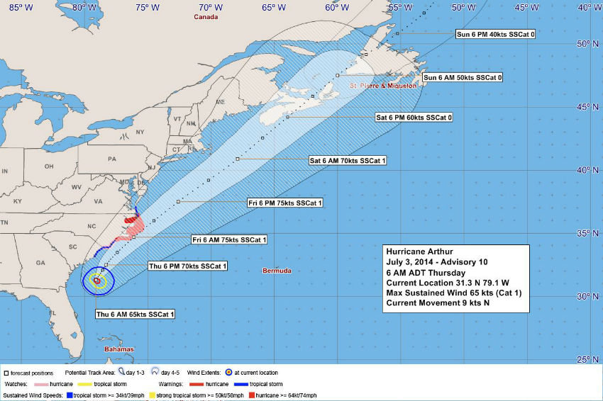
Tropical Storm Arthur — the first named storm of the 2014 Atlantic hurricane season — was officially designated a hurricane by the U.S. National Hurricane Center this morning [July 3].
Currently located 731 nautical miles west of Bermuda, the system has maximum sustained winds of 80 mph and is moving at 9 mph to the north-northeast, the NHC said.
The Bermuda Weather Service said Arthur is not a threat to Bermuda at this time, and its closest point of approach to Bermuda within 72 hrs [3 days] is forecast to be 486 nautical miles to the northwest at 6.00pm on Friday, July 4.
Chart courtesy of the BWS:
In the forecast discussion, BWS’s Jeff Torgerson said, “As Arthur accelerates toward the NE, it is forecast to pass nearly 500nm to the NW of Bermuda Friday evening. Little change is forecast in our local conditions, with 8-12kt S’erly winds veering SW’erly during the night in response to a re-adjustment in the orientation of our dominant ridge. Convergent shower activity is well forecast among models to produce around 10mm of precipitable water through Friday.
“By Saturday, as Arthur begins extra-tropical transition [due to its encounter with the baroclinic upper-level continental trof], a developing and associated frontal boundary will move toward Bermuda, with moderate SW winds veering W’erly by evening, based on excellent agreement in the latest run of the model suite. QPFs are in the 5-10mm range, during the day, and stability indices become favorable by Saturday evening and through the overnight as the front passes from the N.
“A Thunderstorm Advisory will likely be needed with the approach of the front, but no other watches, warnings or advisories are anticipated.”
Photo of Tropical Storm Arthur taken by NASA Expedition 40 crew members aboard the International Space Station, some 227 nautical miles above Earth, taken early on July 2, 2014


Read More About
Category: All, Environment