
Bank Of Bermuda Foundation Triathlon Routes
The Bank of Bermuda Foundation Triathlon is set to take place on October 25 in St. George’s, with the Corporation of St. George advising the public of related routes and road closures.
A spokesperson said, “King’s Square, Ordnance Island, and Water Street East and West will be closed to vehicular traffic from 6.00am until 1.00pm.
“Members of the public who will be attending the event can park at Penno’s Wharf, on the dock as well as in the parking area. Police will be on hand to assist with parking. There will be Police and BTA Marshalls at all junctions along the route to monitor traffic.”
The triathlon’s bike route:
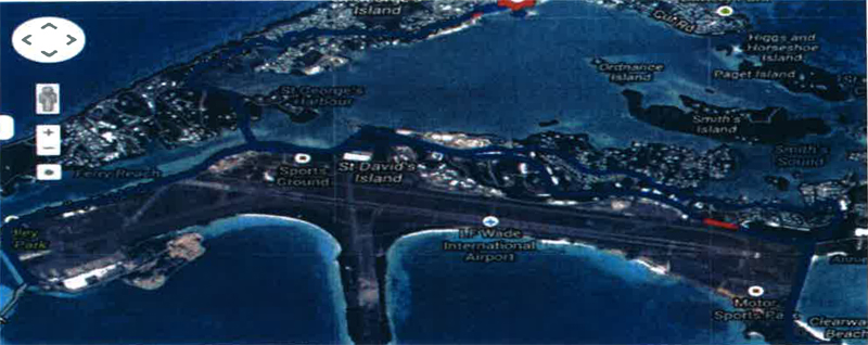
“The bike route [map above] will go left up Water Street, continue up Water Street then up Smiths Hill onto York Street where riders will join the main road. Juniors will continue until Ferry Road, where they will turn around and return to King’s Square making a right turn off York Street.
“This is one lap. 7-10 year olds will do 1 lap. 11-15 will return up Water Street for a second lap.
“Adults will continue over the swing bridge and left onto St David’s Road, take a right turn at Clearwater Middle School, followed by a right onto Tommy Fox Road then almost immediate left onto Pepper Hall Road, straight over the island and down to the BTA shed at Clearwater where they will make a turn around a cone, return back to the island and take a left on Southside Road.
“Before the T junction, the route will take the left on the cycle path rejoining the main road, straight over the island and up the hill then straight over the next island at White’s, straight through the junction past Southside police station and through the gates to the swing bridge roundabout, follow the road to the airport roundabout, and return to the start entering King’s Square off York Street and entering transition from the same side as entered.”
The triathlon’s run route:
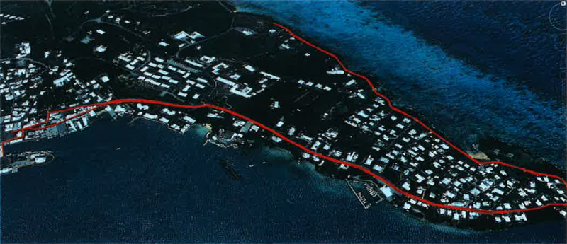
“The run route [map above] will leave T2 on the east side and over the bridge, turn right along the near side of Kings Square running towards the public toilets, head North in front of the public toilets and onto Water Street; this is the one way street above the car park and runners will be with the direction of the traffic.
“Follow Water Street until it joins Mullet Bay Road. Follow Mullet Bay Road to the top of the hill; juniors 7-10 turn around at the top of the hill in the bus stop opposite Old Military Road and return to the finish, juniors 11-15 continue along Mullet Bay Road [becomes Cut Road] and turn opposite the entrance to the boat club and return to the finish, and adults continue along Cut Road [becomes Barry Road] and just turn just before Grenadier Lane and return to the finish along the same route.
“All runners return the way they came with the exception that they continue on Mullet Bay Road [becomes York Street at the bottom of the hill]and make a left turn down King Street and then finish in Kings Square.”
![]()
