NASA Satellite Image Of Tropical Storm Jerry
NASA’s Terra satellite captured an image of Tropical Storm Jerry that “showed wind shear was pushing clouds away from the storm’s center.”
A statement on NASA’s website said, “Forecasters use a variety of satellite imagery to understand what’s happening in a storm, and sometimes just a visible picture can tell a lot. NASA-NOAA’s Suomi NPP satellite provided forecasters with a visible image of the storm that showed wind shear was pushing clouds away from the storm’s center.
“The shape of a tropical cyclone provides forecasters with an idea of its organization and strength. When outside winds batter a storm it can change the shape of it and push much of the associated clouds and rain to one side of it. That’s what wind shear does.
NASA-NOAA’s Suomi NPP satellite passed over Tropical Storm Jerry and revealed wind shear was pushing the bulk of its clouds to the east-northeast of its center. Credit: NASA Worldview, Earth Observing System Data and Information System [EOSDIS]
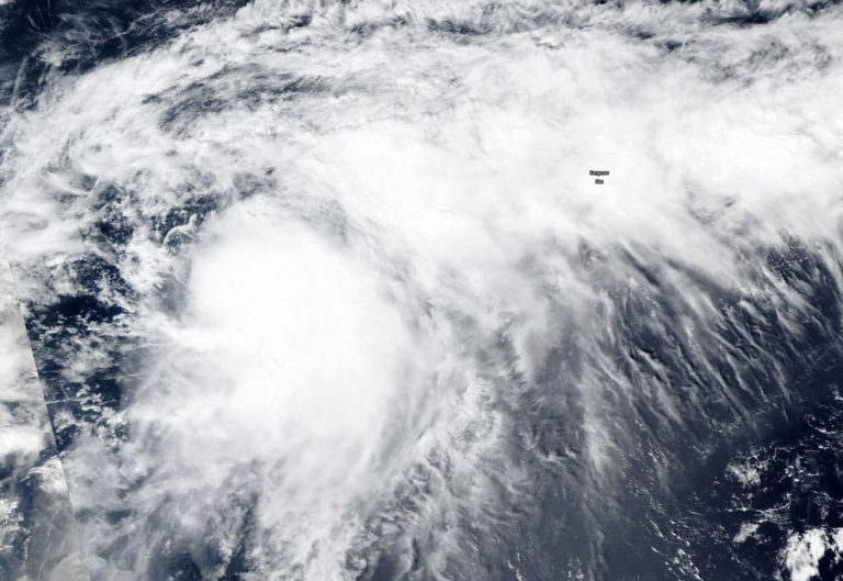
“In general, wind shear is a measure of how the speed and direction of winds change with altitude. Tropical cyclones are like rotating cylinders of winds. Each level needs to be stacked on top each other vertically in order for the storm to maintain strength or intensify. Wind shear occurs when winds at different levels of the atmosphere push against the rotating cylinder of winds, weakening the rotation by pushing it apart at different levels.
“Visible imagery from NASA satellites help forecasters understand if a storm is organizing or weakening, or if it is being affected by vertical wind shear. The Visible Infrared Imaging Radiometer Suite [VIIRS] instrument aboard Suomi NPP provided a visible image of Jerry on Sept. 22. The image showed the bulk of clouds associated with Jerry were pushed to the east-northeast, indicating a west-southwesterly wind shear.
“NOAA’s National Hurricane Center or NHC noted that wind shear was affecting the storm on Monday, September 23, 2019. NHC noted that strong winds shear associated with an upper atmospheric, elongated low pressure area located off the southeastern U.S. coast continues to affect Jerry. That system is creating winds from the west-southwest that are pushing the bulk of Jerry’s clouds and showers to the east-northeast.”