11th Named Tropical Storm Of Season Forms
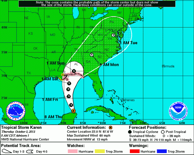
This morning [Oct 3] a mass of low pressure over the southeastern Gulf of Mexico became Tropical Storm Karen, the season’s eleventh named storm.
The Bermuda Weather Service said Tropical Storm Karen is not a threat to Bermuda at this time, and its closest point of approach to Bermuda within 72 hrs is forecast to be 1085 nm to the west at 10am on Sunday [Oct 6].
The U.S. National Hurricane Center — which is deemed essential so still operating during the U.S. federal government shutdown — said Karen has maximum sustained winds of 60mph and is moving north north-west at 13mph.
Graph courtesy of the NHC:
A hurricane watch is in effect for parts of the U.S. Gulf Coast, covering the area from Grand Isle, Louisiana, east to Indian Pass, Florida. A tropical storm watch is in effect from west of Grand Isle to Morgan City, Louisiana, an area that includes metropolitan New Orleans.
Read More About
Category: All


I knew a Karen many years ago…she was always blowing up a storm!
So much for the extra busy hurricane season as predicted early this year inna.
Not complaing. Not complaining at all.
It looks like the weather guys are still trying salvage a season’s worth of hurricane predictions.
Here’s Karen. Waste of a great name. I knew a Karen in high school, lovely, intelligent girl… But that’s another story.
Right now, basically, if two clouds show up within a mile of each other and the National Weather Service can find a whitecap under them, they name it a tropical storm, as in “We predicted a very active tropical season and here’s ALL these storms…”
@nice try…hmmm…would this be your attitude if you were a resident of New Orleans? Or would you be keeping a close eye on the approach of Karen?