NOAA: ‘Near-Normal Atlantic Hurricane Season’
NOAA’s Climate Prediction Center is “predicting that a near-normal Atlantic hurricane season is most likely this year,” according to the National Oceanic and Atmospheric Administration.
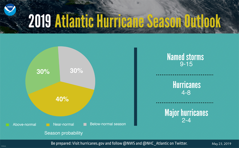
The organisation said, “This outlook forecasts a 40% chance of a near-normal season, a 30% chance of an above-normal season and a 30% chance of a below-normal season. The hurricane season officially extends from June 1 to November 30.
“For 2019, NOAA predicts a likely range of 9 to 15 named storms [winds of 39 mph or higher], of which 4 to 8 could become hurricanes [winds of 74 mph or higher], including 2 to 4 major hurricanes [category 3, 4 or 5; with winds of 111 mph or higher]. NOAA provides these ranges with a 70% confidence. An average hurricane season produces 12 named storms, of which 6 become hurricanes, including 3 major hurricanes.
NOAA graphic showing hurricane season probability and numbers of named storms
“This outlook reflects competing climate factors. The ongoing El Nino is expected to persist and suppress the intensity of the hurricane season. Countering El Nino is the expected combination of warmer-than-average sea-surface temperatures in the tropical Atlantic Ocean and Caribbean Sea, and an enhanced west African monsoon, both of which favor increased hurricane activity.
“New satellite data and other upgrades to products and services from NOAA enable a more Weather-Ready Nation by providing the public and decision makers with the information needed to take action before, during, and after a hurricane,” said Neil Jacobs, Ph.D., acting NOAA administrator.
“The 2019 hurricane season marks the first time NOAA’s fleet of Earth-observing satellites includes three operational next-generation satellites. Unique and valuable data from these satellites feed the hurricane forecast models used by forecasters to help users make critical decisions days in advance.”
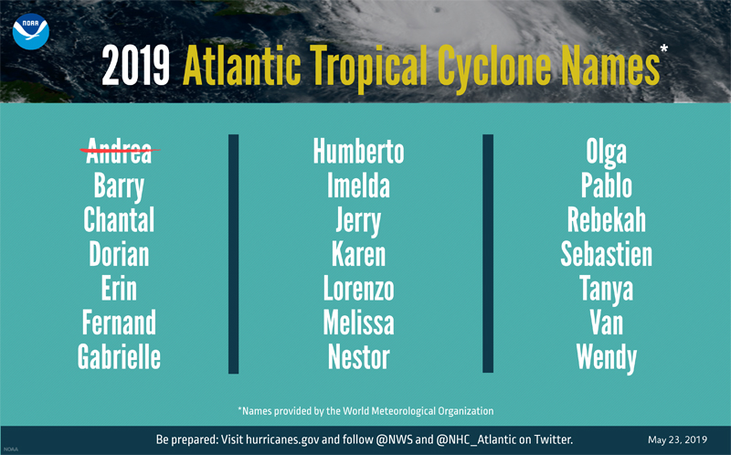
NOAA graphic showing 2019 Atlantic tropical cyclone names
“NOAA’s National Weather Service is making a planned upgrade to its Global Forecast System [GFS] flagship weather model – often called the American model – early in the 2019 hurricane season.
“This marks the first major upgrade to the dynamical core of the model in almost 40 years and will improve tropical cyclone track and intensity forecasts. NOAA is driving towards a community-based development program for future weather and climate modeling to deliver the very best forecasts, by leveraging new investments in research and working with the weather enterprise,” added Jacobs.
“Also, this season, NOAA’s Hurricane Hunter aircraft will collect higher-resolution data from upgraded onboard radar systems. These enhanced observations will be transmitted in near-real time to hurricane specialists at the National Hurricane Center, the Central Pacific Hurricane Center and forecasters at NWS Weather Forecast Offices.
“NOAA’s outlook is for overall seasonal activity and is not a landfall forecast. Hurricane preparedness is critically important for the 2019 hurricane season, just as it is every year.
“NOAA’s Climate Prediction Center will update the 2019 Atlantic seasonal outlook in August just prior to the historical peak of the season.”
Read More About
Category: All, Environment, News


Near normal hurricane season, you say? Now I’m worried. If you had said this was going to be the worst hurricane season in Bermudas’ history then I would have been alright with that. The predictions for local hurricanes seem to often be the opposite of what is stated. Emily comes to mind as one of the worst hurricane predictions (though not the only one) in recent Bermuda history. Let’s wait & see if your upgrade to the American model proves to be more reliable. Either way, I still appreciate the heads up on such matters. Thank you, guys.
Wow, awesome insights. By my analysis I concur that it will most likely be a near normal hurricane season. That is to say not definitely near normal and not necessarily normal, but not far off. I guess we will just have to wait and see…