
Column: Bermuda’s Royal Naval Tanks, Part 2
[Column written by Dr Edward Harris]
In the first part of this article on the Royal Naval Tanks at St. George’s Island, Bermuda, the earliest [1803] published image of the watering facility for British warships was presented. That picture and several others are discussed here in part two.
Discussion of the Porgay Picture of 1803
While Porgay appears to have produced the original artwork for the image from seaward to land from a vessel in Murray’s Anchorage, the aquatint was published by Joyce Gold on Shoe Lane, off Fleet Street in London, but was engraved for publication by John Wells, also a Londoner in the print business. It is dated 28th February 1803 and appears between pages 108 and 109 of the Naval Chronicle, which was also published by Gold and his successor business between 1798 and 1832.
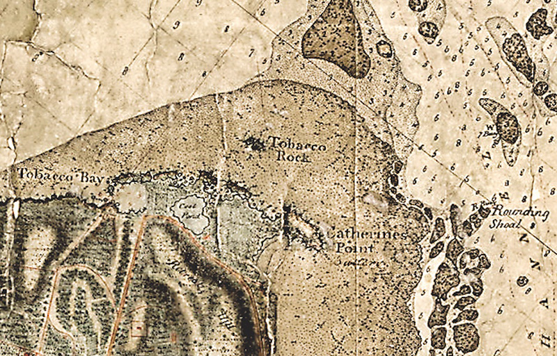
In the 1803 image, a large ship under heavy canvas has just completed a transit of what is now the Narrows Channel, which bounds the eastern coast of St. George’s Island. The ship appears to be flying a pennant, perhaps that of Vice Admiral Mitchell, with a Union flag also high aloft, with possibly a Blue Ensign astern. To the right of the vessel, two lighters carrying flags and four or five oarsmen seem to be making their way through the channel. Between those two boats are several protrusions, which may be the “Tobacco Rock”, the aerial eminence of a reef, signifying the dangers of the approach to Murray’s Anchorage.
Fig. 4. An excerpt from the 1797 Hurd Survey of Murray’s Anchorage at Tobacco Bay, appearing to show the Naval Tanks and also Tobacco Rock, which may be recorded in the 1803 Porgay image. [National Museum of Bermuda.]
On a tack that might suggest a collision, the “ship of the line” is heading for another such warship anchored near the Narrows, with all sails furled. That ship carries a Union flag on the main mast, with three others, including possibly a blue or red ensign at the stern: gunports are evident on both vessels. A can or cask buoy lies ahead tilted in the prevailing wind of the day, with some iron strapping, suggesting a barrel-type construction similar to mooring buoys found in a ditch at the Bermuda Dockyard in the early 1980s. An iron eye at the top indicates its use as a permanent mooring buoy, rather than a channel marker of which the Hurd chart shows several in red or white in the Narrows.
Three other vessels complete the seaward ensemble, two in Murray’s Anchorage and another likely anchored in Tobacco Bay. The nearest vessel is a small sloop with its classic “Bermuda Rig” [invented on the Island before 1674] with a skipper and crew of one: perhaps this was an inshore pilot boat, as ocean-going such vessels were often in the form of two-masted gigs. The wind that day was coming from the northeast. To the west of the sloop is another small boat, apparently of three masts, two of which carry square-rig sails: it may be heading into Tobacco Bay to pick up water for the warship at anchor.
On the land, Fort St. Catherine, first built in 1613 and its third configuration by 1803, stands atop a high hill, a little exaggerated, overlooking the turn of the Narrows into the spacious waters of Murray’s Anchorage. Behind and westward rises the slope of a hill which later culminated in Forts Victoria and Albert, constructed some 25 years later. A number of “pencil-cedars”, that is, Juniperus bermudiana, dot the hillside but may have been more densely forested than suggested, although at this period cedar was much in demand as the Royal Navy put in orders for Bermuda sloops as advice vessels, since they were the fastest vessels afloat in their day.
On the right the peculiarly eroded rocks on the north side of Tobacco Bay appear, with a gap allowing the artist to envisage the scene within the little harbour, a boat lying central to the open space. To the landward of the boat is a building with two windows flanking a central door. Behind the building is a white space enclosed by a wall with openings, perhaps to alleviate the force of heavy winds on the structure.
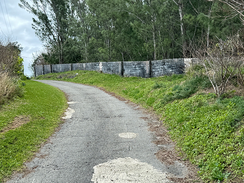
Shown in a map of 1854, the trapezoidal space is the “watercatch” for the tank, shown in brown with two internal dividing walls. Adjacent is the “Keeper’s Dw[elling]. House” and to the left is a squarish catchment, which may have had a tank below [as Savage in 1901 references “tanks”] or fed its water into the tank at the bottom of the trapezoidal water catch. The perimeter wall of the watercatch was extant in 2023, but the catch itself is a forest of invasive casuarina trees.
Fig. 5. A detailed excerpt from an 1854 map of St. George’s Island at “Tank Bay” showing the divisions in the water tank, in brown, at the foot of the water catchment in light orange. [National Archives Kew.]
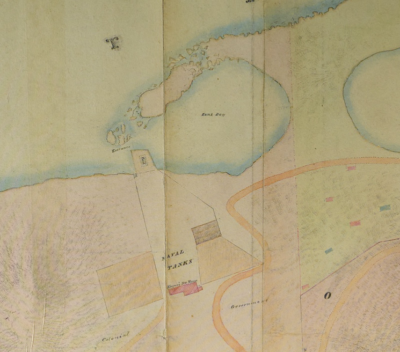
Fig. 6. Another 1854 map of the “Naval Tanks” identifies two “catches” and one tank, plus a “field” down to the “watering place” on the Bay. [National Museum of Bermuda.]
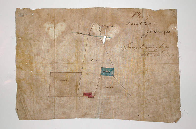
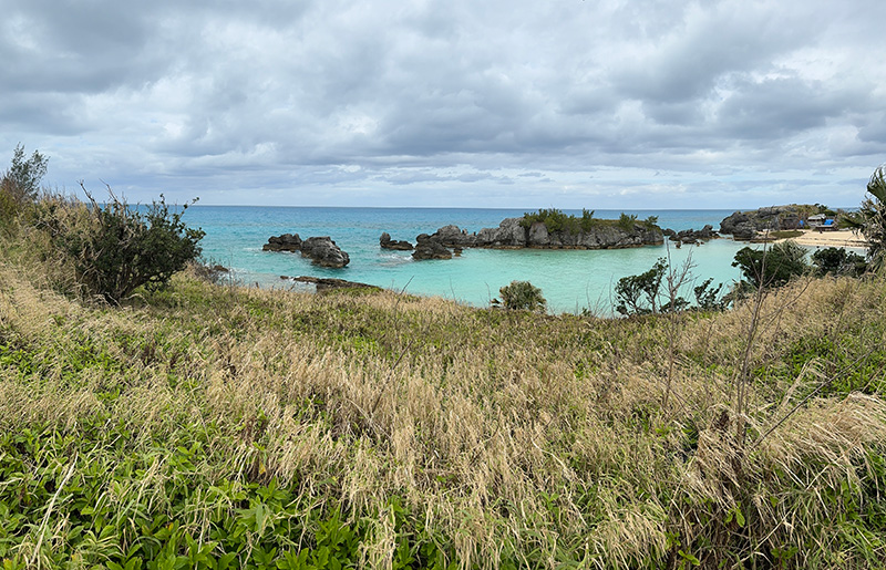
This is a typical Bermudian arrangement wherein the ground is scrapped of soil and rendered, then whitewashed, to form the “catch” for rain. On what was likely a manmade peninsular in the bay, there a “Pond”, which may have been a subsidiary tank from which water could be drawn. On one of the 1854 charts, Tobacco Bay has become “Tank Bay”, while the “Naval Tanks” survived to be recorded on the Savage Survey of 1900. The first warship to take on water from Tobacco Bay was HMS Hermione in 1796, the year before a famous mutiny took place on the vessel in the West Indies.
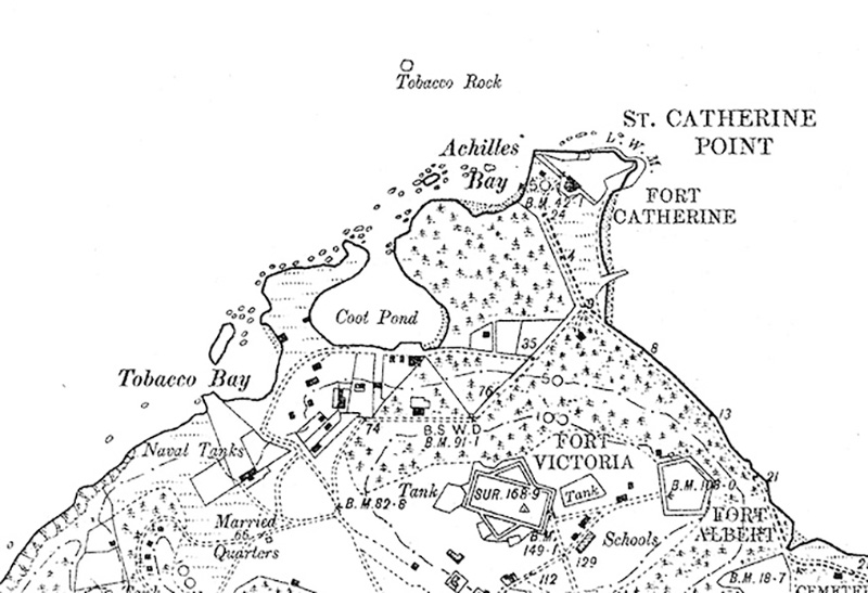
Fig. 7. The “Naval Tanks” as recorded in the Savage Survey published at as the Ordnance Survey in 1901.
Not shown in later surveys is an extension to the water tank building to the left, from which in the 1803 image extends a line down to the boat in the Bay. In the present description of the 1803 picture in the Wellcome Collection, that is seen as being “a system of buckets on a rope brings water down from the cistern to the shore” [enquiries with the Wellcome in late 2023 stated that that comment was from their staff, as no such description was found on their copy of the 1803 image].
The boat appears to have a derrick and it is possible that the rope carried the buckets directly to the vessel, which could have contained casks for the water. Two men, possibly soldiers, with a flag on the hillside to the west of the tank complete the activity in the 1803 picture at Murray’s Anchorage and Tobacco Bay.
According to Dr. Henry Campbell Wilkinson in his 1973 work, Bermuda from Sail to Steam, the tanks were completed in 1796 and cost some £2,400: “Wm. Smith the controller [of Customs] was contractor for the tanks. These were lined with 68,000 bricks at $16 a thousand. Wm. S. had grown up in England and come to the island in 1792. He was a cousin of Major Wm. Smith of Riddell’s Bay.
He became mayor of St. George’s in 1798”, following the sudden death of the esteemed Major Andrew Durnford RE, the first mayor of the town, who first suggested the location of Tobacco Bay for water tanks. Wilkinson reproduced the 1803 image from the Naval Chronicle [opp. p. 84], sadly without an extended caption. The image had currency for a considerable period, as it also appeared in Royal Naval Commander Ian Stranack’s, The Andrew and the Onions, subtitled “The Story of the Royal Navy in Bermuda 1795–1975”, in the later 1970s.
Fig. 8. As painted, looking west, in the mid-1830s, the Naval Tanks property was enclosed by boundary walls [Dr. Johnson Savage 1833–36. National Museum of Bermuda].
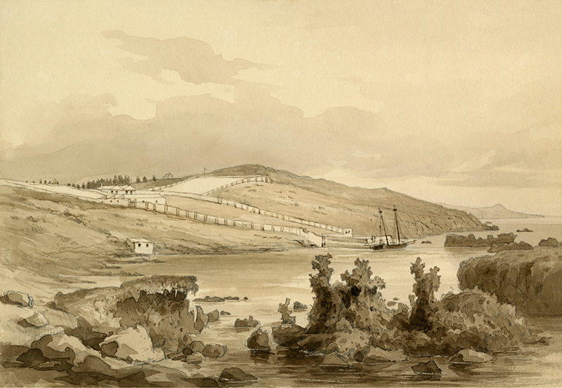
Fig. 9. The eastern boundary wall of the Naval Tanks Catchment in 2024: the catchment is a forest of invasive casuarinas, an Australian pine.
An account of the tanks appeared in the 1840 edition of the Nautical Magazine, which also referenced other aspects of Bermuda in an extensive article. That reference is quoted in Dr. Adrian Webb’s seminal volume on the Hurd Survey of Bermuda, published in 2016 by the National Museum of Bermuda, as below.
Fig. 10. Tobacco Bay in 2024, looking north with Murray’s Anchorage in the background.
“The men-of-war are supplied with water from two large tanks built on the slope of the northern ridge, aback of St. George town. The water which falls from the clouds, and is received into reservoirs at the foot of the plastered platforms, is clear and cool; it is pumped up from these receptacles to a level with pipes, which convey it down the declivity, into a hollow cylinder of rude construction at the landing place equally primitive in a snug little cove, [inappropriately termed “Tobacco Bay,”] at the foot of the hill, and the casks are filled in the boats by means of a hose; when expedition is required, some of the casks are conveyed up the ascent, filled to [? at] the tanks and rolled down to the boats.”
Overall, the 1803 image is one the earliest pictorial representation of the coming of the Royal Navy to Bermuda, a major change and influence on Bermuda society that only ceased at the end of the Cold War in 1995, when the North America and West Indies Station was closed, much to the regret of many, after two hundred years of association with the Island and its people.
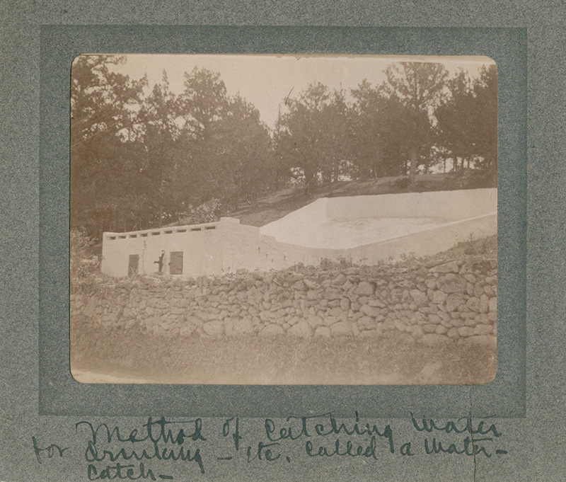
Fig. 11. The water tank and eastern “water-catch” at Tobacco Bay would have looked like the one in this photograph, except that it was likely a bit larger. [Bermuda National Trust.]
- Dr Edward Harris
