Weather Service Issues Tropical Storm Watch
[Updated - scroll to bottom for latest]
The seventh tropical storm of the 2011 Atlantic hurricane season has formed, and the Bermuda Weather Service [BWS] said the system is a “threat to Bermuda.”
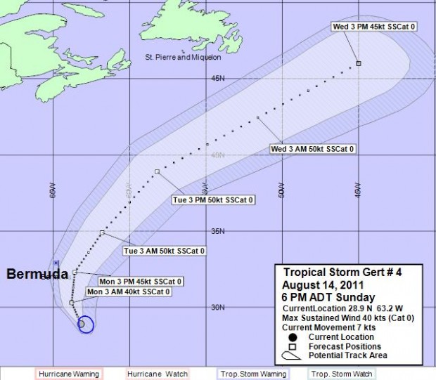
This morning [Aug.14] BWS said the closest point of approach to Bermuda within 72 hrs is forecast to be 63 nautical miles [72 miles] to the east south-east at 7am tomorrow.
They issued a Tropical Storm Watch valid from tonight through Monday, and a Thunderstorm Advisory valid from early this morning.
This morning the U.S. National Hurricane Center [NHC] said the depression was about 300 miles [480 kilometers] south-southeast of Bermuda and is “moving towards Bermuda.”
“The center of the depression will approach Bermuda tonight or early Monday,” said the NHC. It had maximum sustained winds of 35 mph [55 kph], and was moving west-northwest at 10 mph [17 kph].
The NHC said some strengthening is forecast during the next couple of days, and the depression could become a Tropical Storm later today.
For today’s forecast the BWS said, “A few more showers are possible early today as low pressure moves by to the north.”
“Otherwise Sunday promises to be fine, before tropical moisture in association with Tropical Depression 7 moves in from the south with further showers and increasing winds.”
“There is a risk of tropical storm force winds developing into Monday as it moves by our area. As such a Tropical Storm Watch remains posted.”
Update 2:00pm: The system has now been upgraded to Tropical Storm Gert. It has maximum sustained winds of 40mph, and is expected to strengthen further over the next 48 hours the NHC said.
Update 6:30pm: Chart above updated. The latest update from BWS said Tropical Storm Gert’s closest point of approach to Bermuda will be 61 nm to the east at 2pm tomorrow. They said: “Winds and showers will increase tonight as Tropical Storm Gert strengthens and moves into our area from the south. Tropical storm force winds are expected to develop mainly over the eastern marine area by early Monday, and slowly taper in the afternoon, as the system moves by our area.”
Update 6:50pm: The NHC said the storm’s maximum sustained winds have increased to 45mph.
Update 9:20pm: At 9pm the BWS said Gert’s losest point of approach to Bermuda will be 61 nm to the east at 2pm tomorrow [Aug.15]. It is now 185 nm south south-east of Bermuda.
Forecaster Jeff Torgerson said, “Rain and showers are expected to amount to up to 1-3 inches potentially across the area, with heavier amounts toward the east, while seas/SE swells are not expected to reach over 9 feet at the peak, with a relatively short-lived development of the storm to this point.”
“The wind forecast again, is not so much based on model data (consistent in holding generally light and backing winds over the Island), but on the storm track and intensity forecast by NHC.”
“Strongest winds of 25-35 knots with gusts to 45 knots are expected over the eastern marine area, while the Bermuda forecast holds moderate to strong winds, with gust to gale force. ”
“Gusts are expected to be strongest in and around heavier shower and thunderstorm activity, which, again is most likely to the east of the Island.”
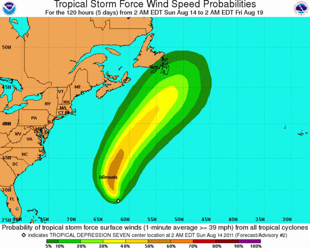
- First graph courtesy of BWS, second NHC


How do we find out if flights tomorrow will be affected please? Is 35mph too strong for planes to land?
I’m wondering the same thing?
As you know we have no news on Z.B.M. on the weekend ,and V.S,B.has their last newscast at 12.15 on sunday ….so we only have Bernews to depend on, by the way who won the power boat race today?
We believe D13 – with Bobby DeCosta & Chris Wells – was first across the line, but waiting on official confirmation of that…
Roger, from what I have experienced, flights are cancelled with winds 45mph or more.
Planes can land safely in winds higher than 35 mph as long as the wind is the same direction as the runway or very close to it. Winds (not sure if 35 mph or 35 knots ) perpendicular to the runway is when plans may not land .
They will ground flights in windws excess on 30 mph. Plan to stay extra days.
Thanks for the info Rob.
is the british airways flight still operating tomorrow night?
It takes really, REALLY bad weather for B.A. to cancel their flights. I remember one hurricane a few years back(can’t recall which one) was really close and all incoming flights but B.A. were cancelled. We were on Kindley Field Rd. watching the flight come in and the plane was coming in flying almost totally sideways instead of level-no exaggeration.
My hubby and I were like ‘Oh my God!’ because we thought there was something wrong. It looked like the plane was going to roll over and crash land. There were other spectators there as well and we all thought ‘we need to get out of here’ because we thought for sure we were going to see a plane crash in Bermuda. However, at the very last minute-like when it just passed Ferry Reach and was going over Kindley Field Road-it straightened completely and landed. We all were just looking at each other in amazement. I swear I’ve never seen anything like it in my life.
Apparently they were flying like that because of the wind and something to do with aerodynamics (as we later found out). I have the utmost respect for British Airways and their pilots after seeing that, let me tell you!
I believe that type of landing is called a crab landing as the plane is sideways (you know, crabs crawl sideways). Pilots do it when there are crosswinds but you’re right in that it could be dangerous. It takes a lot of skill and judgement to straighten at the precise moment. I’ve heard that all British Airways pilots are former military pilots; don’t know if that is true or not.
On another note, I wonder if businesses,offices, etc. will be closed tomorrow? Nothing much seems to be happening as yet. If things get worse, will there be radio announcements and the like? What about the Causeway? I’d love to sleep in and get a day off. Wonder if it will happen???
Unlikely that we’ll have a day off. Takes a full scale hurricane, and we’ll work until just before it’s due to hit. This is just a blow.