
New Draft Marine Protected Area Maps
The Blue Prosperity Plan has unveiled revised draft maps for the proposed marine protected area [MPA] network which “highlight significant changes that accommodate feedback received from the commercial fishing industry.”
A Government spokesperson said, “After extensive consultation, a series of new draft maps were revealed that form the proposed marine protected area [MPA] network as part of Bermuda’s Blue Prosperity Plan. These new draft maps highlight significant changes that accommodate feedback received from the commercial fishing industry during the public comment period, focus group sessions, and one-on-one discussions with individual commercial fishermen. The modifications to the MPA network also reflect the Bermuda Ocean Prosperity Programme’s [BOPP’s] careful consideration of concerns regarding the impacts of the MPA network on the maintenance of critical infrastructure, future tourism development, complexities of the fishing industry, and the ability of the network to meet conservation-related objectives.
“The priority through this initiative is the replenishment of our fisheries, not restricting activity or benefits within our marine environment. The revised network still protects valuable nursery habitats that ensure healthy fish stocks for generations to come. However, the benefits of MPAs aren’t just about fish, although those are the most talked about. By safeguarding nursery areas, in addition to a variety of other marine habitats–including seamounts–the draft network provides Bermuda with much-needed resilience to impacts from climate change, such as stronger and more frequent hurricanes. A series of smaller protected areas that include fully protected areas also helps maintain marine biodiversity. This design helps prevent the collapse of entire marine ecosystems, which support a large portion of the island’s tourism industry.
“Modifications were made to the sizes, locations and levels of protection of many of the MPA sites initially proposed in both the nearshore and offshore regions. The new maps, which are not final, were presented to focus group participants at a recent meeting to gather additional feedback on whether the changes effectively captured their input. Stakeholders representing a variety of industries and interest groups, including commercial fishing, had the opportunity to provide comments and ask questions about the updated maps.”
“We were glad to have a diverse group of stakeholders present to learn about the modifications to the Blue Prosperity Plan and its proposed Marine Protected Area maps,” said a BOPP spokesperson. “Fruitful dialogue and continued engagement from all parties has strengthened the document and allowed BOPP to make meaningful adjustments to the original maps that were released last year.”
The spokesperson said, “Acknowledging that multiple ocean stakeholders were involved in this process, additional modifications were made to accommodate the specific needs and concerns of the utilities, shipping and tourism sectors, as well as the BOPP Science Committee. Protection designations were changed in key areas to allow for ongoing shipping activities, as well as necessary maintenance of critical infrastructure, such as channel dredging, moorings and docks. In areas where fully protected MPAs were adjacent to hotel-owned land, adjustments were made that will allow for future permitted tourism development and provide hotel owners with flexibility in pursuing tourism activities, such as habitat restoration, that are compatible with the Marine Spatial Plan’s conservation objectives.
“These maps are not final versions; however, they do represent months of hard work to incorporate as much feedback as possible from ocean user groups while still meeting the stakeholder-approved objectives that guide the Marine Spatial Plan. As a result, the newly proposed MPA network does a better job of reducing user conflict and meeting conservation-related objectives.
“The Draft Blue Prosperity Plan is currently being updated. A final draft will be published, inviting any written comments from interested members of the public. Those submissions will be reviewed by an independent committee. Any recommendations made by that committee, together with the draft plan, will be submitted to the Cabinet in the coming months. The voices of Bermuda’s people have been essential to creating a plan for a thriving and sustainable ocean for Bermuda, both now and into the future.
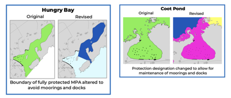
“The two sets of maps above show how the new draft MPA network has been modified to allow for maintenance of critical infrastructure, including moorings and docks, which was a concern raised by multiple stakeholder groups. [Note: Not the final version]
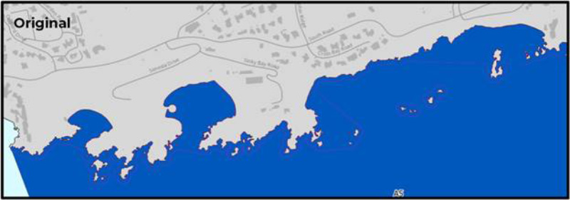
‘In the original draft MPA network, the fully protected area [the darker blue colour] extended to the shoreline in a region that is important to both the Reefs Resort & Club and the Hamilton Princess Beach Club. The designation of full protection would have prohibited any extractive activities, including fishing and future development.
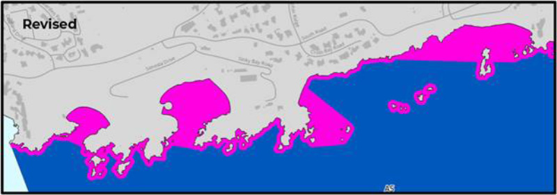
“In the revised draft MPA network, a partially protected buffer [the pink colour] is placed between the shoreline and the fully protected area [the darker blue colour]. This provides hotel owners with the flexibility to pursue permitted development activities, as well as tourism activities that are in line with the Marine Spatial Plan’s conservation objectives.” [Note: Not the final version]

Read More About
Category: All, Environment, News
“After extensive consultation …”
I am not sure that the commercial fishermen would agree that description.
It looks like the original plan tried to grab as much area as possible in the hope that there would be no pushback.
So Walter Roban and his BOPP crew of save the world billionaires are hell bent on distroying livelyhoods and eliminating one of our cultural hobbies and past times that we enjoy with our children and grandchildren. Yes Bermuda, there will come a day in the not so distant future when fishing off the rocks will have become a thing of the past or enjoying a days boating while hanging a line over the side of our boats.
It would have been easier to swallow this if there were statisics and data collection spanning decades in which one could clearly see what species were impacted and by what percentage. The sad reality is that they have zero data and zero statisics on our fisheries. There have never been any records kept by our fisheries department to support this.
Minister Roban is ignoring the fishermens knowledge of decades and generations while listing to foreign billionaires who claim they have all the answers about an Island and its fisheries that they’re not even connected to. Bermuda people, wake up before its to late, lets not allow the wool to get pulled over our eyes. BOPP is not the answer, not in Bermuda. What we need and should have had in place was proper policing of catch and record keeping while instituting bag limits for recreational fishermen. This would clearly show us what condition our fisheries and local waters were in.