
BWS: Hurricane Erin Is A ‘Potential Threat’
Hurricane Erin is “a potential threat to Bermuda”, the Bermuda Weather Service said this evening, with its nearest forecast point to Bermuda being 382 nm to the west at 6pm Wednesday [August 20] with the BWS noting that “forecast is subject to change with the next update.”
Graphic courtesy of the BWS:
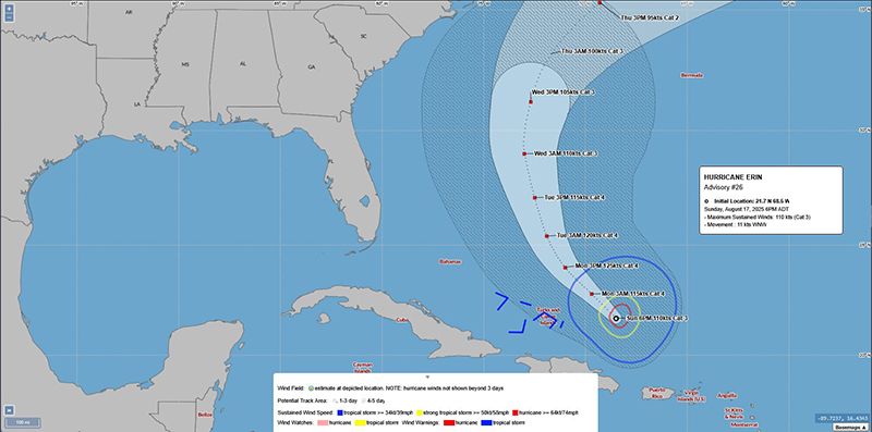
The latest forecast from the U.S. National Hurricane Center said, “At 500 PM AST [2100 UTC], the center of Hurricane Erin was located near latitude 21.7 North, longitude 68.5 West. Erin is moving toward the west-northwest near 13 mph [20 km/h].
“This general motion is expected today, followed by a gradual turn to the northwest and north on Monday and Tuesday. On the forecast track, the core of Erin is expected to pass to the east and northeast of the Turks and Caicos Islands and the southeastern Bahamas tonight and Monday.
Graphic courtesy of the NHC:

“Maximum sustained winds are near 125 mph [205 km/h] with higher gusts. Erin is a category 3 hurricane on the Saffir-Simpson Hurricane Wind Scale. Some increase in size and strength is forecast during the next 48 hours. Erin is likely to remain a dangerous major hurricane through the middle of this week.
“Hurricane-force winds extend outward up to 50 miles [85 km] from the center and tropical-storm-force winds extend outward up to 205 miles [335 km].
“The estimated minimum central pressure is 946 mb [27.94 inches].”
