Weather Service Issues Tropical Storm Watch
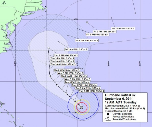
[Updated, scroll to bottom for latest] Hurricane Katia is now packing winds of near 215km/h, and has been upgraded to a category 4. It is not expected to directly pass over Bermuda, however forecasters are predicting increased winds over the island due to the system passing 240 nautical miles to our west.
In their latest update the U.S. National Hurricane Center said, “Maximum sustained winds have increased to near 135 mph [215 km/h] with higher gusts. Katia is a category four hurricane on the Saffir-Simpson hurricane wind scale. Some fluctuations in strength are possible during the next 24 hours…Followed by slow weakening.”
At 11:30pm this evening [Sept.5] the Bermuda Weather Service [BWS] said Katia’s closest point of approach to Bermuda within 72 hrs is forecast to be 241 nautical miles to the west, at 4am on Thursday, September 8, 2011.
“Hurricane Katia, roughly 415 miles to our south, is a potential threat to Bermuda. Strong winds with occasional gale force gusts will arrive on Tuesday, ahead of Katia, and continues through Thursday.”
“A few showers will be around Tuesday through Wednesday morning, then showers and the chance of thunder increases Wednesday afternoon through Thursday,” said the BWS.
Update Sept 6, 7:30am: In their latest update this morning, the U.S. National Hurricane Center said Katia has been downgraded to a Category 3 hurricane, and its maximum sustained winds have decreased to near 125 mph.
At 6am today, the BWS said Katia’s closest point of approach to Bermuda within 72 hrs is forecast to be 239 nautical miles to the west north-west at 11am on Thursday, September 8th.
“Hurricane Katia, varying from a category 3 to category 4 cyclone, is a potential threat to Bermuda. Strong winds with occasional gale force gusts will arrive by this evening and will continues through most of Thursday. A few showers will be around today through Wednesday morning, then showers and the chance of thunder increases Wednesday afternoon through Thursday,” said the BWS.
Update 12pm: The BWS has issued a Tropical Storm Watch.
Update 4pm: Government has issued an advisory.
Update Sept.7, 6:30am: Katia has been downgraded to a Category 1 hurricane


Every one be prepared for hurricane Katia , just in case .
Mark, this is very good advice. When we start becoming overconfident, we wind up in a whole heap of trouble. Rather be prepared for nothing than unprepared for something.
Will the regiment be required to go in for the storm? haven’t herd anything bout it!
That is not planned at this time, as the hurricane is not really going to hit us. Like Triangle Drifter says below, we in for some extra winds, not a hurricane impact as such.
Mark, you qualify for a job at The Weather Cnannel. Drama & scaring the public for no good reason. The information is right at your fingertips direct from the Hurricane Center, where TWC & all the rest of them get their info, showing that we are outside of the cone for even TD force winds. Expect nothing more than typical winter storm force winds.
http://www.nhc.noaa.gov/text/refresh/MIATCMAT2+shtml/060832.shtml?
I don’t think there is anything wrong with Mark’s comment. Mother nature will do what it wants and being prepared for it is the smart thing to do.
Don’t forget what happened with Hurricane Emily in 86′.
* Don’t forget what happened with Hurricane Emily in 86′. *
Emily was a direct hit after it tracked over the Dominican Republic and raced towards us overnight.
The US forecasters monitoring her at the Base thought she was going to go on a more westerly track and slide between us and the US East Coast and didn’t bother warning us.
Google ‘Track hurricane Emily 1987′ and see !
Yep, & hurricane understanding & prediction has improved a whole heap since hurricane Emily. Emily blew up from not much overnight catching everyone offguard. We have been watching Katia for over a week & it has been very close to predictions all along.
Yes I – Sorry mate – Emily was Sept 25th 1987.