BWS: Tropical Storm Arthur A “Potential Threat”
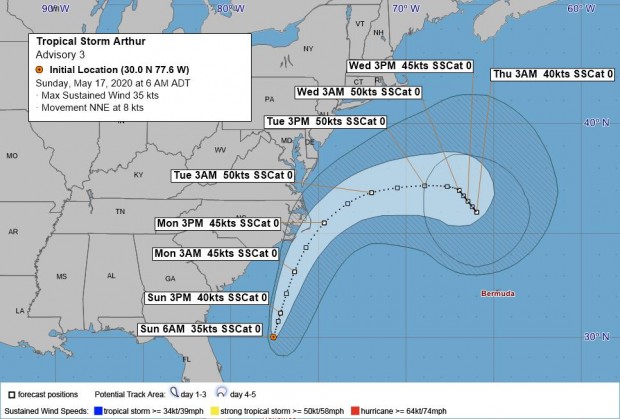
[Updated] Tropical Storm Arthur — the first named storm of the 2020 Atlantic Hurricane Season — is a “potential threat to Bermuda,” the Bermuda Weather Service said.
Graphic courtesy of the BWS:
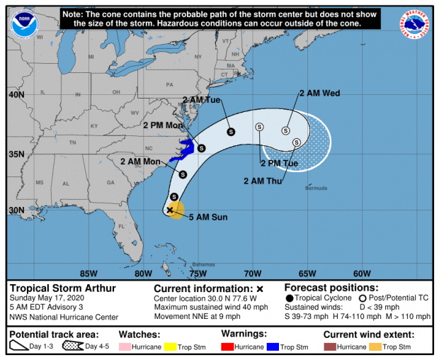
The latest forecast from the U.S. National Hurricane Center said, “At 500 AM EDT, the center of Tropical Storm Arthur was located near latitude 30.0 North, longitude 77.6 West. Arthur is moving toward the north-northeast near 9 mph [15 km/h]. A turn toward the northeast with an increase in forward speed is expected during the next 24 to 48 hours.
“On the forecast track, Arthur will remain well offshore the east coast of Florida, Georgia, and South Carolina today, and then move near or just east of the coast of North Carolina on Monday.
“Maximum sustained winds are near 40 mph [65 km/h] with higher gusts. Some strengthening is forecast during the next 48 hours. Arthur is likely to lose its tropical characteristics on Tuesday.”
Graphic courtesy of the NHC:
Update Sunday, May 17, 7.55am: The system, which was a Depression yesterday, has now become Tropical Storm Arthur, and the BWS said that it is a “potential threat to Bermuda.”
The BWS said its closest point of approach to Bermuda within 72 hrs is forecast to be 293 nm to the NNW at 6am on Wednesday, May 20, noting that “this system may move closer to Bermuda after this time period depending upon its track.”
Update 1.50pm: The Minister of National Security Wayne Caines advised that the Emergency Measures Organisation [EMO] is “closely monitoring Tropical Storm Arthur.”
Minister Caines “assures Bermuda that all steps are being taken to ensure the island is prepared, and reminded the community that as we are less than two weeks away from the start of hurricane season, now would be a good time to assess their emergency plans and storm supplies”.
Minister Caines said, “We are very cognizant of the anxiety and concern that people experience with an approaching storm. Against the backdrop of what we are dealing with as a country with COVID-19, I want to assure the community that we are taking all the necessary precautions to ensure that Bermuda is storm ready and that our people are protected.
“We know that for some this can be an overwhelming time, so as a reminder, should anyone wish to seek support or comfort as we navigate through this, they can call our Emotional Well-being Hotline at 543-1111.”
Minister Caines added, “Due to COVID-19, the EMO has been meeting on a regular basis, and tomorrow as part of our normally scheduled meeting, Tropical Storm Arthur will feature prominently in our discussions.
“Lastly, Hurricane Season is from June 1 – November 30, and meteorologists have indicated that this year’s season has the potential to be particularly active due to warmer temperatures. Tropical Storm Arthur has kick started the season off early and it’s a timely reminder that we should all be sufficiently prepared. To follow the latest developments associated with this storm system visit www.weather.bm.”
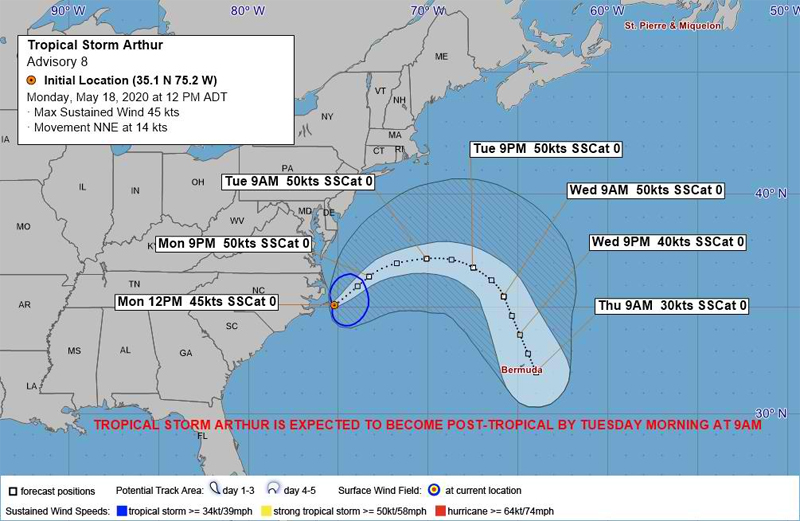
Update Monday, May 18th 7.55am: The BWS still states that Tropical Storm Arthur is a “potential threat to Bermuda,” with its closest point of approach to Bermuda within 72 hrs forecast to be 35 nm to the NNE at 6am on Thursday, May 21, with the BWS noting that “this system may move closer to Bermuda after this time period depending upon its track.”
Their forecast for today states, “Tropical Storm Arthur will pass to our distant northwest tomorrow before it is then projected to re-curve and possibly pass to our near north as a post-tropical system.
“Before this occurs, we can expect a surge of warm, moist air to envelop the area with more cloud than sun and possible rainy periods and showers. A light to moderate breeze will continue until late Tuesday when winds will possibly become strong until early Thursday as the system approaches.”
Update 12.20pm: Tropical Storm Arthur is a “potential threat to Bermuda”, the BWS said, with its closest point of approach to Bermuda within 72 hrs is forecast to be 30 nm to the ENE at 6am on Thursday, May 21, noting that “this system may move closer to Bermuda after this time period depending upon its track.”
Graphic courtesy of the BWS:


Not as much threat as the CS not helping with our crisis.
Why are we panicking over a miniature storm. Cmon people!!!