
Google Street View Adds Bermuda Highlights
[Updated] A new update made to the Google Street View application has been released to the public, giving people from around the world the ability to enjoy a 360-degree view of many of Bermuda’s unique sites, with Google saying Bermuda was added as we are an “important destination in terms of tourism and culture.”
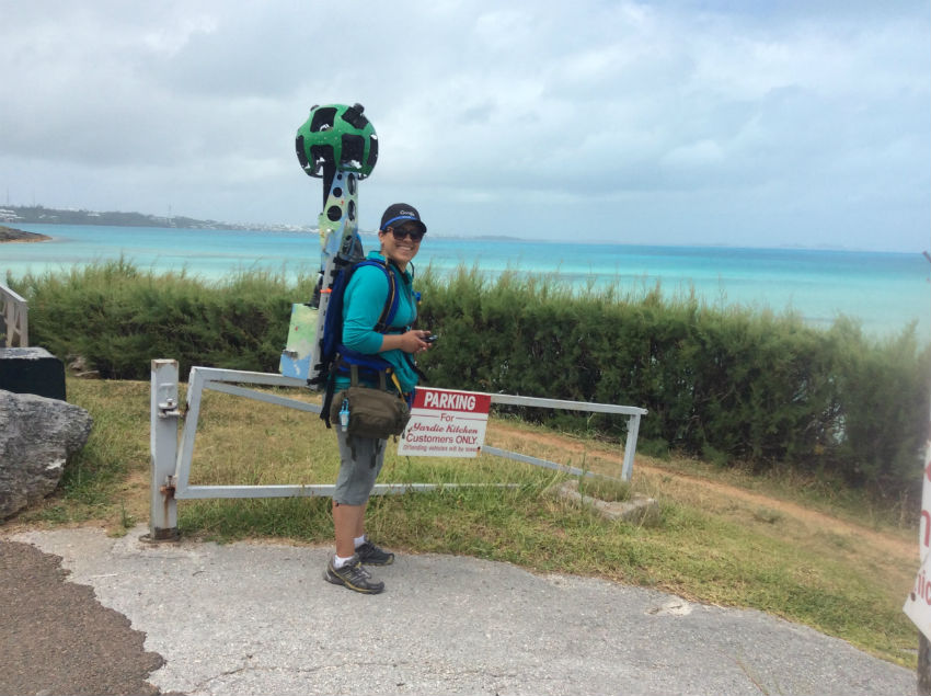
The update was made possible thanks to Google’s Street View Trekker, a camera system made small enough to make the leap from cars to backpacks; a Street View Trekker camera operator was spotted at Shelly Bay in May 2015.
Screenshot of Google Street View’s Bermuda Collection page:
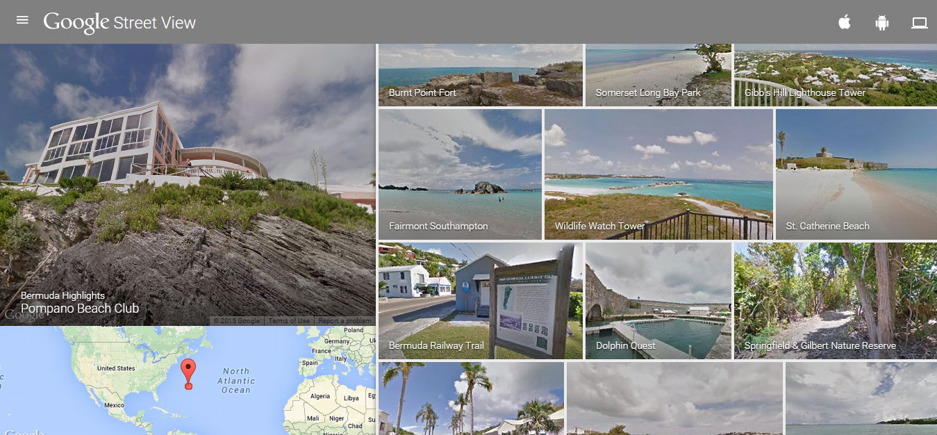
Dubbed the Bermuda Collection, the update includes unbeatable looks at a number of the island’s destinations, including Fairmont Southampton’s private beach club and Turtle Hill Golf Club, Pompano Beach Club, Burnt Point Fort, Somerset Long Bay Park, Gibb’s Hill Lighthouse, Wildlife Watch Tower, St. Catherine Beach, Bermuda Railway Trail, Dolphin Quest, and the Springfield and Gilbert Nature Reserve.
It also includes Rosewood Tucker’s Point, the island’s shoreline, Shelly Bay Beach, Fort St. Catherine, the National Museum, Grotto Bay Beach Resort, BAMZ, the city of Hamilton, Church Bay Beach, Jobson’s Bay Beach, Elbow Beach, Clearwater Beach, Fun Golf, St. David’s Lighthouse, the National Sports Centre, Chaplin Bay, Warwick Long Bay, the Botanical Gardens, and Admiralty House Park.
A Travel Pulse story said, “Using the Street View Trekker, Google’s latest camera system in the Street View fleet, Google was able to provide picturesque shots of some of Bermuda’s best landmarks – and best-kept secrets.
“The Street View Trekker is similar to the camera system used on the cars for Google Street View, except it’s been shrunken down to a 40-pound backpack with 15 cameras that can be worn around, according to Google Street View Program Manager Deanna Yick.”
A Street View Trekker camera operator working at Shelly Bay in May 2015:
“Yick said Bermuda was chosen for the latest collection because “it’s a very important destination in terms of tourism and culture.” Specific sites were chosen based on their popularity.”
“According to Google, the collection is designed to “inspire readers who are planning beachy trips over the next year… in the spirit of prolonging the summer” as the season winds down. The Bermuda collection also furthers Street View’s goal, Yick said, to “provide a digital view of the real world,” to “make the world smaller” and to “bridge cultures.”
“Just because the road ends doesn’t mean there aren’t other interesting sites to see.”
To visit Google Street View’s Bermuda Collection, click here.
Update 11.27am: A Parks Department spokesperson said, “Starting this week many of Bermuda’s National Parks have been added to the Google Street View repertoire, allowing people around the world to have the visual experience of being on the ground in these beautiful locations.
“Street View is described by Wikipedia as “a technology featured in Google Maps and Google Earth that provides panoramic views from positions along many streets in the world.”
“For example, if you go to www.instantstreetview.com and type in ‘Botanical Gardens, Camden, Bermuda’, you will be able to see some stunning images of the Botanical Gardens and even virtually ‘walk’ some of the trails.”
“This will bring massive international exposure for the Island and some of its most captivating settings,” said the Minister of Public Works Craig Cannonier. “People across the world will be able to virtually wander along the beaches of South Shore Park or the through the Botanical Gardens or Arboretum, and fall in love with the beauty of this place from the comfort of their homes.”
“The initiative began in late 2014 when representatives of Google Maps contacted the Department of Parks in Bermuda to seek permission to capture high resolution imagery of numerous points of interest across the Island to add to their extensive Street View product.”
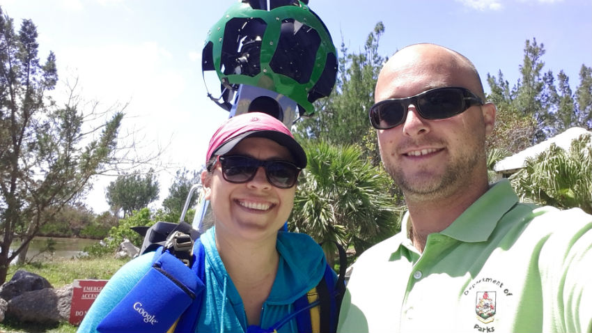
Google’s Street View Special Collects’ Hope Garza and Department of Parks’ Assistant Park Planner Justin Lavigne:
“The variety of locations available to choose from continues to grow with roads, trails, beaches and even the inside of buildings being added to the offerings.”
“The historic properties and forts in and around the UNESCO World Heritage Site Town of St. George were of particular interest to the Special Collects team at Google Maps,” said Minister Cannonier. “During early discussions between the Department of Parks and Google Maps a number of National Park properties that would be excellent additions to this project were identified and included in the collection schedule.”
“The Operator from Google’s Street View Special Collects team, Hope Garza, arrived in May 2015 to begin capturing imagery.”
“The Department of Parks assigned our Assistant Park Planner, Justin Lavigne, to assist Ms. Garza with her data collection in National Parks,” explained Director of Parks Lisa Johnston. “His role was to transport the Operator and equipment, known as a ‘Trekker’, to various National Parks and guide her through all of the main features and walking trails.
“It was important that the Trekker was paused any time that steps were being retraced to avoid collecting an excess of redundant data so the Assistant Park Planner’s detailed knowledge of the parks was an essential asset to the project. Over a period of two and a half months, the Assistant Park Planner guided Google’s Operator through over 20 National Parks, including beaches, forts, and the entire Railway Trail.”
Update 3.32pm: The BTA’s Glenn Jones said, “Like our partners in the Department of Parks, the Bermuda Tourism Authority is excited about the new Bermuda Collection on Google Street View.
“It allows potential travellers dreaming about Bermuda to imagine themselves on our spectacular Atlantic coastline where our parks, beaches, cultural attractions and trails are some of the best in the world.
“The BTA has been telling consumers of an experiential travel opportunity awaiting them in Bermuda and this rich, visual content from Google will help us tell that story more fully.
“After our teams in Bermuda and New York assisted Google with immigration and other logistics earlier this year, we are all very pleased to see the final result today.”

Read More About
Category: All, News, technology
Great exposure. Thanks Google!
Seen those camera cars a number of times across the US & Canada.
Would be nice to have a street view of at least the major roads here.
Take it a step further, a waterview around the Islands shores, close in. Need a skipper who knows all of S Shore inside the reefs well? I’m here.
People spend hours of time cruising Google Earth. The streetview feature has been put to good use many times.
Google also added Street View to the main roads and even the railway trails. Just go to Google Maps.
The shores of the east end were collected. Bad weather prevented the collection of the rest of the shoreline, for now.
Please don’t take pictures at the moment as the parks and nature reserves are so over grown and in need of attention along with the road sides. The cane grass is as high as myself at Ferry Reach Park when we went to see the glow-worms, the grass so high we could not close the car doors where we were parked. Some of the areas that have been cut back have been ‘hacked’ and look awful. Where oh where are the men who love to do this job. We have the ones who really don’t want to be doing it. Also, why not have a shredder visit the cutting site to mulch up the cut items instead of leaving the cuttings on the banks to rot which looks worse than the over-grown foliage. Come on guys/gals love your island and be happy for the job you have and do it well.
Hog Bay Park is looking terribly overgrown too… as is St. Davids Head.
Anyone know where you can get a full street map of Bermuda? You’d think that Google could complete that before adding pictures.
South Shore Road.
North Shore Road.
Front Street.
Middle Road.
Stop and ask.
Jingus……….
Too bad it’s at a time that our roadside vegetation is so neglected & overgrown… Always keep your home clean, you never know who may stop by to pay a visit.
Great coverage. Well done.
Hopefully they don’t show the sad state of our Botanical Gardens and that awful scar in the middle of it. No doubt tourists are thoroughly impressed when they see it
Spittal pond entance areas are overgrown as many above have stated the islands side roads are overgrown and look horrible! It’s embarrassing, is everyone on holiday ???? Most beautiful time and when you expect visitors, you leave the vegetation in this state?