Nicole Upgraded, BWS Issues Hurricane Warning
[Updated: The Bermuda Weather Service has just issued a Hurricane Warning and the NHC has just announced that Nicole has become a hurricane, with maximum sustained winds near 75 mph [120 km/h] with higher gusts. The BWS said Nicole’s closest point of approach to Bermuda within 72 hrs is forecast to be within 25 nm of [or directly over] the Island at 11am on Thursday, October 13th.]
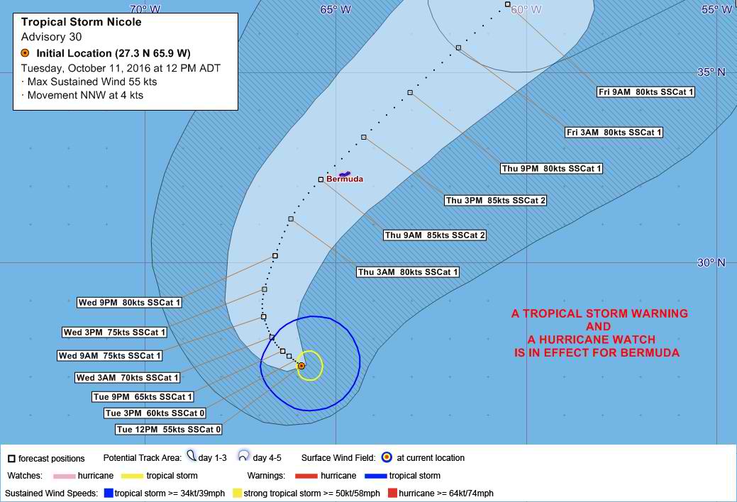
As of the 12pm forecasts today [Oct 11], both a Tropical Storm Warning and Hurricane Watch are in effect, with the BWS saying that Tropical Storm Nicole is predicted to be within 25 nm of [or directly over] the Island at 11am on Thursday, while the NHC says “Nicole is forecast to become a hurricane later today or tonight.”
Tropical Storm Nicole is “a threat to Bermuda,” the Bermuda Weather Service said, with its closest point of approach to Bermuda within 72 hrs forecast to be “within 25 nm of [or directly over] the Island at 11am on Thursday, October 13th.”
The BWS said, “Nicole is forecast to intensify to a hurricane later this afternoon and pass overhead early Thursday as a Category 2 hurricane.
“Ahead of Nicole’s approach expect hazardous conditions including strong winds, heavy rain, thunderstorms and dangerous surf & rip currents. Tropical storm force winds arrive by Wednesday evening with hurricane force winds arriving late Wednesday night into early Thursday morning.”
Graphic courtesy of the BWS:
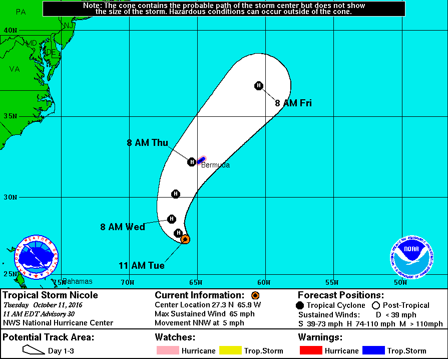
The latest forecast from the U.S. National Hurricane Center says, “At 11.00am, the center of Tropical Storm Nicole was located near latitude 27.3 North, longitude 65.9 West.
“Nicole is moving toward the north-northwest near 5 mph [7 km/h]. This general motion should continue today. A turn toward the north and an increase in forward speed is expected tonight, followed by a northeast turn on Wednesday.
“On the forecast track, the center of Nicole is expected to approach Bermuda Wednesday night and pass near Bermuda Thursday morning.
“Maximum sustained winds have increased to near 65 mph [100 km/h] with higher gusts. Additional strengthening is forecast during the next 48 hours, and Nicole is forecast to become a hurricane later today or tonight. Tropical-storm-force winds extend outward up to 105 miles [165 km] from the center.”
Graphic courtesy of the NHC:
In a statement last night, Minister of National Security Jeffrey Baron said, “Nicole is a serious threat to Bermuda, and we cannot afford to have complacency with this storm.
“The Bermuda Weather Service has confirmed that this will be a strong, slow moving Category 1 hurricane and I cannot emphasize enough the critical importance of residents securing their homes and completing their preparations well in advance of this storm,” the Minister said.
Yesterday the Government advised that the EMO will convene another meeting today, and said “following that meeting the public will be advised regarding further public safety, storm and public service advisories.”
Update 2.52pm: The Bermuda Weather Service has just issued a Hurricane Warning and the NHC has just announced that Nicole has become a hurricane.
The NHC said, “maximum sustained winds have increased to near 75 mph [120 km/h] with higher gusts. Additional strengthening is forecast during the next day or two.”
“Hurricane-force winds extend outward up to 30 miles (45 km) from the center. Tropical-storm-force winds extend outward up to 105 miles [165 km] from the center.”
The BWS said Nicole’s closest point of approach to Bermuda within 72 hrs is forecast to be within 25 nm of [or directly over] the Island at 11am on Thursday, October 13th.


If all predictions are a direct hit or coming very close, why hasn’t there been any sense of urgency to produce an action plan by the EMO? DO BETTER!
You want me to wipe your butt too? This storm has been on the radar for a long time. Grow up and make your own decisions and stop blaming others.
An avocado wipe…….lmaooooo
I was referring to the action plan when it comes to school closures and other government entities I have no control over. If you take your head out of ur a$$ and not be so condescending, you could have figured that out.
They’ve been warning us about it for about a week now.
If you have no ‘sense of urgency’ about it that’s your own stupid fault.
Would you like the members of the EMO to come round & do all the preparation for you?
What are you talking about? There have been notices from the EMO, the Govt, the Minister, private insurers etc for days now.
@ why no sense of urgency, I could not agree with you better, Bernews as soon as you can could you please give a listing this evening of all closures, where and when, since our Government is taking to long.
People need to make arrangements, because some employers are darn right insensitive and are more interested of how long they can remain open. I must take my hat off to Bank of Butterfield for making their announcement early enough, so their clients and customers are aware of their early closure tomorrow, and that their staff can take care of their homes and families.
Minister Baron take the lead out and get with it, Mikey is not in charge of the job no more, YOU ARE.
Thanks to our Forefathers who had de Wisdom to build our dwellings out of de resourceful lime stone rock, which evolved to concrete blocks.
De most secure resistant dwellings in de world when it comes to withstanding hurricane force.
Be safe
We are urgent. liquor stores will be rammed Wednesday night…lol. Just getting rid of the access now though.
What category was Fabian when it impacted Bermuda in 2003?
“On Friday, September 5th, 2003, the bad news forecasted came to fruition as Fabian came within 50 miles to the West of Bermuda. Just as close as a direct hit as you can get. Wind gusts increased by the hour on the island until at about 3 PM EDT when reports came from the island of 117 mph sustained winds with gusts up to 127 mph. Sustained winds would be in the area of 120 mph with gusts up to 130 mph”
I was told back then that the anemometer tower at Harbour Radio went down with a 168mph gust
Nicole is forecast to pass slightly to the west, same as Fabian. It’s also high tide. Not looking good for the causeway.
I think the answer he was looking for was a simple:
It was a Cat 3.
A strong 3.
You could have ’3′ and it’d actually be answering his question.
Best of luck guys.
Secure as best you can and leave a lee window open.
After watching the webcam on FB it’s already kicking up from the north.
Shalom.
I was told you don’t need anemometer if you have a wife.
Where is the EMO? Business need to know what Government and the Chamber Of Commerce are doing, lets hear something. Individually we know how to prepare.
why does the forecast here report the winds as MPH and K/PH and the Bermuda weather service issues in KNOTS?
Lets see some consistency here as not too many folks know that:
1 knot = 1.15 mph
1 mph = 1.609 kph
@Why No Sense of Urgency
I understand what ya saying but just because they don’t seem like they are worried what’s stopping you? Just do you and try to help others, ya busy waiting on them how bout u board up ya house. If a cow comes crashin shru ya window during d strom you can’t blame the EMO so just worry about you
My house was boarded by last night. I handle my business when I need to but I was asking as a consideration to the public as to what businesses and roadways were going to be closed. If we know that the storm is projected to hit or come as close as a hit, then why it’s take EMO so long for them to have an action plan? Here it is, end of day Tuesday and EMO is late to the punch with information. They should have had a meeting at 9am with preliminary information circulating soon after. This isn’t our first rodeo with hurricanes and we’re not reinventing the wheel!
This is concerning. Some models and pro mets are suggesting that this intensifies even further than 100mph, to 110+ mph, AT LEAST. D: