Hurricane Humberto Is “Threat To Bermuda”
[Updated: BWS now lists Hurricane Humberto as a "threat to Bermuda"]
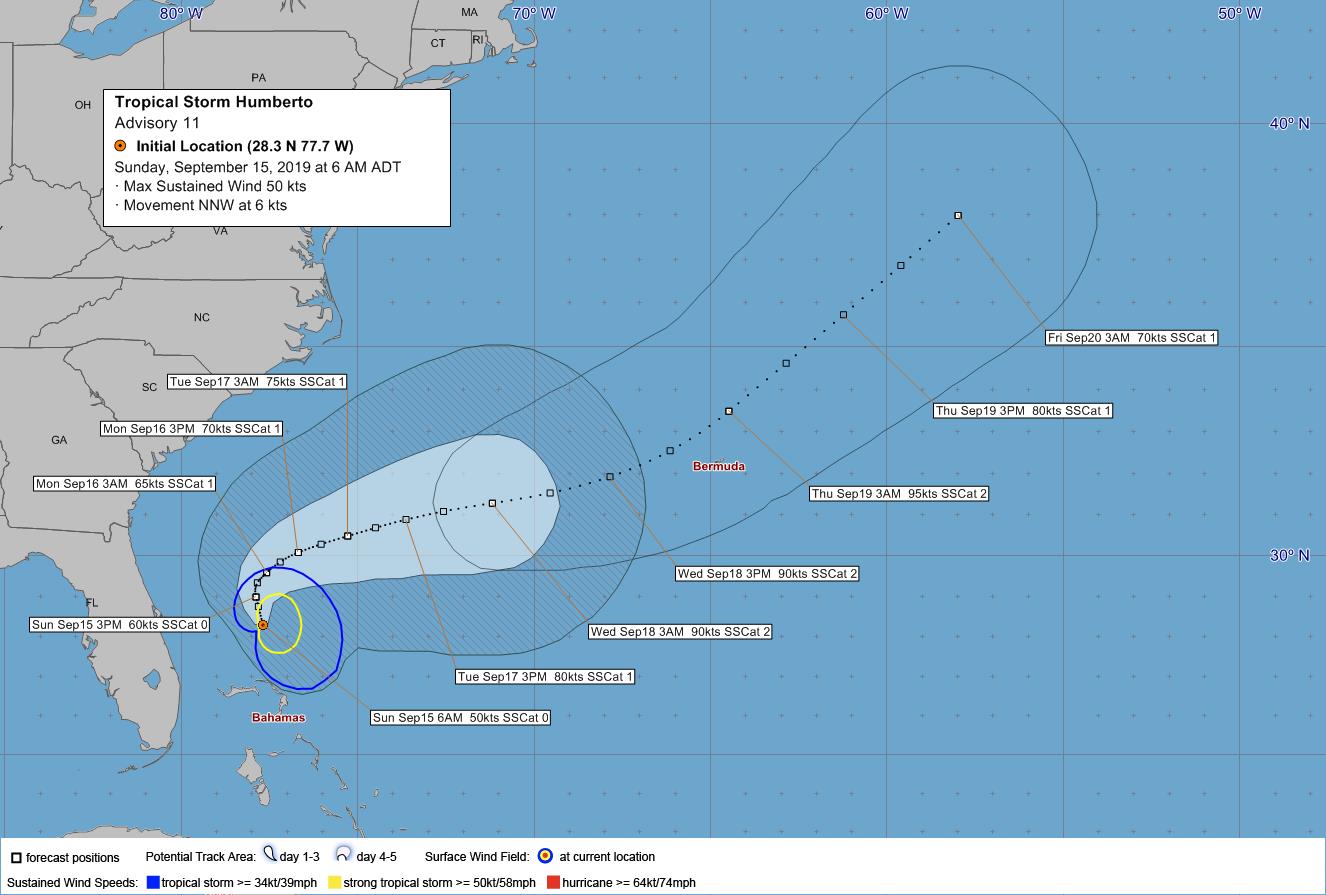
Hurricane Humberto is a “potential threat to Bermuda”, the Bermuda Weather Service said, with its closest point of approach to Bermuda within 72 hrs forecast to 287 nm to the WSW at 6am on Wed, September 18th, with the BWS noting that “this system may move closer to Bermuda after this time period.”
The BWS forecast states, “Tropical Storm, probable Hurricane Humberto, is now a potential threat and may bring tropical storm to storm force winds on Wednesday.”
Graphic courtesy of the BWS:
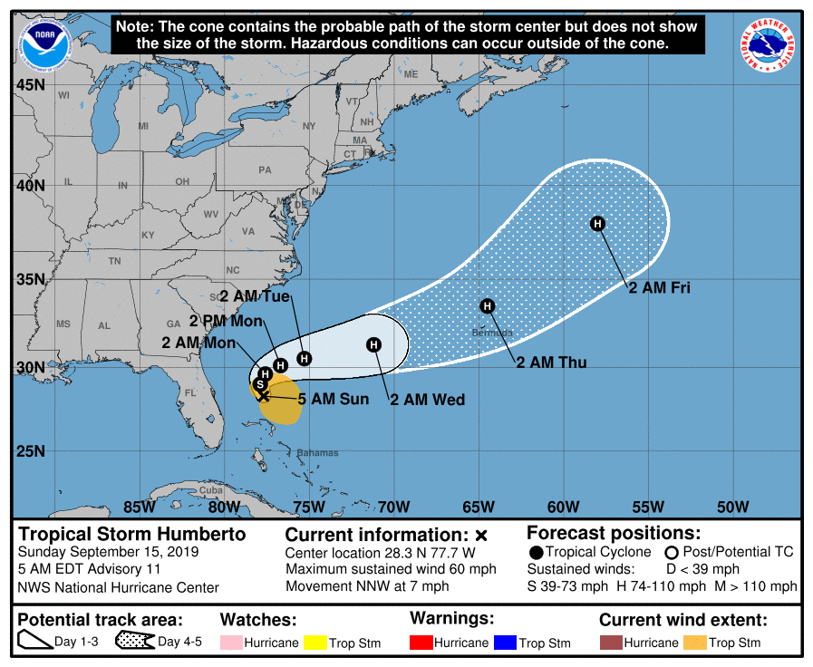
The latest forecast from the U.S. National Hurricane Center said, “Maximum sustained winds are near 60 mph [95 km/h] with higher gusts. Strengthening is expected during the next few days, and Humberto is forecast to become a hurricane later today or tonight. Tropical-storm-force winds extend outward up to 160 miles [260 km] from the center.
Graphic courtesy of the NHC:
Update 11.55am: A statement from the Government is below:
The Ministry of National Security is advising that the Emergency Measures Organisation (EMO) is closely monitoring the track of Tropical Storm Humberto which is forecast to become a hurricane.
“The EMO is prepared and stands ready to convene should the weather system’s forecasted track pose a threat to Bermuda.”, said Minister Caines. “The next update will be on Monday. For more information, please visit www.weather.bm.”
Minister Caines added, “I take this opportunity to remind the public that Bermuda is in the midst of hurricane season (June 1 – Nov. 30). I strongly encourage the public to revisit your business, household and family preparedness plans.”
As a reference, the public are advised to note some of the storm preparedness tips below:
- Securing homes and checking storm shutters. Finalizing any repairs around the house.
- Having the necessary supply of batteries, including a backup battery / power supply for cell phones.
- Having at least two weeks supply of medication for yourself, other family members or pets.
- Updating first aid kits.
- Checking gas canisters for use.
- Having necessary unperishable food supplies in the house.
- Have an analogue phone in case the power goes out
- Have a radio that runs on batteries that can tune into the Emergency Radio Station 100.1fm
Update 12.12pm: The BWS 12pm update states that its closest point of approach to Bermuda within 72 hrs is forecast to be 202 nm to the west at 12pm on Wednesday [Sept 18], with the BWS noting the “system may move closer to Bermuda after this time period depending upon its track.”
Update 6.15pm: The BWS 6pm update states that its closest point of approach to Bermuda within 72 hrs is forecast to be 165nm to the west at 6pm on Wednesday [Sept 18], with the BWS noting the “system may move closer to Bermuda after this time period depending upon its track.”
The BWS states, “Tropical Storm Humberto is expected to reach hurricane status this evening and remains a potential threat. Local conditions will be affected by the dangerous seas and large area of rainfall pushing out ahead of Humberto’s centre. Gusty tropical storm winds with hurricane force gusts may begin as early as Wednesday.”
The NHC 6pm update states, “Maximum sustained winds have increased to near 70 mph [110 km/h] with higher gusts. Further strengthening is expected during the next few days, and Humberto is expected to become a hurricane later tonight.”
Update 11.42pm: The NHC confirm that Humberto is now a hurricane, with maximum sustained winds having increased to near 75 mph [120 km/h] with higher gusts.
Update Mon, Sept 16 – 12.01am: The BWS continue to say that Humberto is a “potential threat to Bermuda”, with their 12am forecast stating that its closest point of approach to Bermuda within 72 hrs is forecast to be 146 nm to the west at 12am on Thursday [Sept 19] with the BWS noting “this system may move closer to Bermuda after this time period depending upon its track.”
Update 6.45am: The BWS said, “As of the 6am advisory, Hurricane Humberto was upgraded to become a threat to Bermuda. Today, retreating high pressure will give way to developing showers.
“Local conditions will continue deteriorate thereafter, with dangerous seas then rain and gusty thunderstorms pushing out ahead of Humberto’s centre. Tropical Storm force winds with hurricane force gusts may begin as early as Wednesday evening.”


Folks this is a Tropical Storm now but forecasted so far to be Cat 2 Hurricane passing to our north. Most pass to our south.
It remains a serious threat to us unless we see some change in direction.
So please follow the National Hurricane Service’s website daily and prepare. Make sure your family, friends and neighbors know what’s happening too.
We don’t want another Faye, that most didn’t know was coming…
Lord knows we domt want another Fahey.
And the idiot speaks yet again.
LOl.EVERYBODY SAY, NO MORE FAY, NO MORE FAY.
I bet you’re proud of yourself for this comment. Small things.
I honestly think that the BWS shouldn’t state “Closest point of approach to Bermuda within 72 hrs (3 days) is forecast to be…” until the storm is actually forecast to be under 72 hrs away. Otherwise, it’s a horribly misleading statement.
As an extreme example, the 5-day cone of uncertainty could have Bermuda directly in the storms’ path on the final forecast point for the fifth day, but – because BWS are only quoting closest point of approach within three days – the headline distance could make it seem as if the storm will be hundreds of miles away and not impact Bermuda. This could lead to complacency in terms of storm preparedness. I’ve heard at least one person say something along the lines of: “Oh, you’re worried about that storm!? It’s meant to be 200 miles away from us at the closest point. That’s not a threat at all.”
So why not just leave it as “This storm is a potential threat to Bermuda” when it’s forecast to be over 72 hours away and then switch to giving forecast closest points of approach when it’s within that threshold?
Very good point!
I disagree. Everyone knows what ‘within 72 hours’ means. It doesn’t tell you the direction of the storm. What you’re suggesting is that they give less information.
Hoew about when we hear the words potential threat “get ready”
Carnival Breeze is docking at 4:00 pm on Monday will any businesses be opened or will they be closest?
Why is the hurricane larger than Bermuda?
The island isn’t the larger
It wouldn’t be a hurricane if it were smaller.
Cause we are tiny, like O’J's brain.
Trump will make it go away with a Sharpie.
Or a nuke.
cruise ship Carnival Breeze will deck @ 4.00pm on monday and stay till tuesday. Should the cruise line cancel docking ,since all the business will be boarded up?
Why would businesses be boarded up on Tuesday?
The storm is expected on Thursday – or has Agent Orange been playing with the Sharpies again?
As we are overgrown with trees and bushes, power will go out in many places. Too many trees near power lines. I don’t understand why they are not regularly maintained…poor Regiment guys will have to clean up after the storm what Government should be on top of. Hope it is minimal.
Many trees are on private property. The Owners should be doing their part.