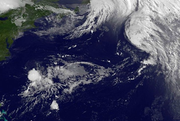
NASA Photo: Tropical Storms Bret & Cindy
Two tropical storms brewing in the Atlantic were captured on one image by NASA today [July 21]. Both storms – Bret and Cindy – are hundreds of miles to the east-northeast of Bermuda and pose no threat to land areas.
NASA’s GOES Project issued an infrared image of both Bret and Cindy today from the GOES-13 satellite. The image was captured at approximately 5:45am Bermuda time and shows Bret about 405 miles east-southeast of Bermuda, while Cindy is about 975 miles east-northeast of Bermuda.
NASA said, “At 5 a.m. EDT, Bret was still holding on to tropical storm status with maximum sustained winds near 40 mph, just over the 39 mph threshold. It was moving to the northeast near 8 mph and is expected to continue in this direction while speeding up and weakening over the next couple of days.”
“Bret’s center was near 33.1 North latitude and 71.7 West longitude. Bret is expected to dissipate by the weekend. Infrared satellite data from the Atmospheric Infrared Sounder (AIRS) instrument on NASA’s Aqua satellite indicated that the cloud top temperatures in the southern quadrant of the Bret are as cold as -70 Celsius, indicating strong, high thunderstorms and strong convection.”
“Meanwhile Tropical Storm Cindy developed overnight from System 99L that NASA was watching yesterday afternoon. Cindy developed into Tropical Depression 3, and quickly grew into a tropical storm and got her name.”
“As of 5 a.m. EDT today, July 21, Cindy’s maximum sustained winds were near 60 mph, and she’s expected to strengthen over the next day before colder waters sap her energy.”
Read More About
Category: All


