
NOAA On The Volcanic Origins Of Bermuda
Bermuda has long been known to sit atop an extinct, mid-ocean volcanic seamount but geologists remain divided on why and when the eruptions which gave birth to the island took place.
An extensive study by the US National Oceanic and Atmospheric Administration [NOAA] looked at the conflicting theories on the island’s volcanic origins in 2009.
NOAA concluded the oceanic crust surrounding the base of the Bermuda volcano is estimated to have formed 123 to 124 million years ago at the Mid-Atlantic Ridge, the submarine mountain range running along the axis of the Atlantic Ocean.
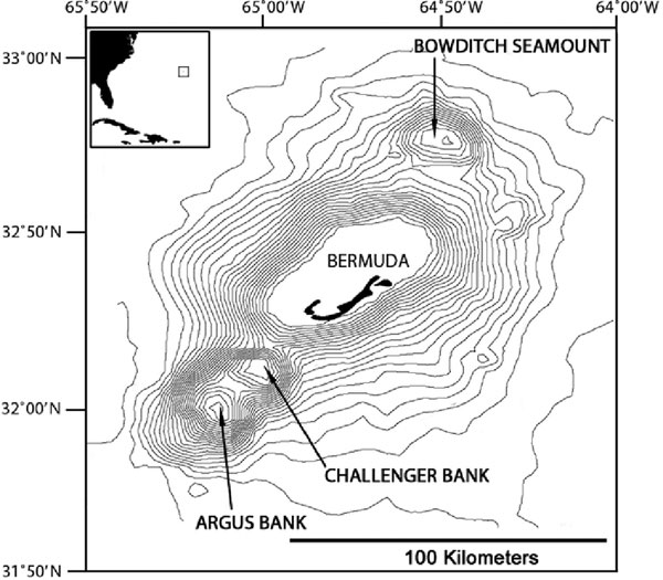
Extending toward the ocean’s surface are four northeast-to-southwest trending volcanic peaks, including the emergent Bermuda Pedestal and the submerged Challenger, Argus, and Bowditch seamounts. The islands of Bermuda are located along the southeast margin of the largest peak, the Bermuda Pedestal.
Bermuda islands and Pedestal along with the adjacent Argus, Challenger and Bowditch seamounts
Several theories have been proposed as to the origin of the Bermuda volcanoes. Initially, scientists believed that a large, underwater volcanic eruption along the Mid-Atlantic Ridge approximately 110 million years ago established a series of volcanic peaks that moved westward with the North American tectonic plate [as the Atlantic Ocean widened by plate tectonics and seafloor spreading]. However, this interpretation is not well supported by the much younger age of volcanic rocks recovered from deep drill cores in Bermuda.
Today, the most visible evidence of Bermuda’s volcanic past are two calderas that can be seen from from an aerial view of the island [pictured below]. Calderas are formed when the weight of a volcano’s explosions become too much for it to handle, causing it to collapse in on itself, leaving behind a crater like shape.
In this case, the two calderas enclose two of the islands many bays, the Great Sound and Castle Harbour.

NOAA said while it is now generally accepted that the four peaks comprising the Bermuda seamounts were formed by extensive volcanic activity occurring approximately 33 million years ago, why the eruptions occurred at this time and place is still being debated by geologists.
One theory hypothesises that the volcanism occurred over a hot spot or plume in the Earth’s crust. A newer theory proposes that the volcanic activity occurred due to a worldwide reorganisation of the planet’s tectonic plates that occurred due to the closing of the Tethys Ocean [when Arabia collided with Eurasia during the Cenozoic Era, 35 to 40 million years ago].
Based on the current area of the Bermuda Pedestal and the maximum elevation of other mid-ocean volcanoes, the elevation of the original Bermuda volcano would have been about 3.280 feet. Using typical shoreline erosion rates, it would have taken from three to 10 million years to reduce the island to sea level.
Cross-section view across Bermuda Pedestal showing relationship between limestone & volcanic rocks
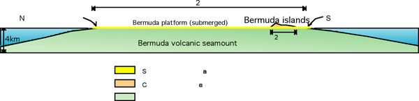
As the original volcanic peaks of Bermuda were eroded below sea level by wave action, coral reefs formed in the shallows and limestone from calcareous algae and corals began depositing during the early Pleistocene [about 1.8 million years ago].
Today, a thin limestone cap — about 49 to 328 feet thick — completely covers the underlying volcanic rock.
During the Pleistocene, alternating glacial and interglacial periods, with associated changes in sea-level, resulted in the deposition of a series of limestone layers predominantly composed of carbonate eolianites [remnant sand dunes that were converted to rock], with a few marine deposits and terra-rossa paleosols [ed fossil soils composed of wind blown dust from the Sahara Desert in North Africa].
The carbonate eolianites and marine limestones would have formed during interglacial periods of higher sea levels when the platform was submerged, while the paleosols formed during times of glaciation and low sea-levels. Cycles of cementation, erosion, and re-cementation occurred due the fluctuations in sea level. Six to nine interglacial stands are represented in the rock layers that vary in their age and structure.
The surface of Bermuda is characterised by karst terrain, a landform where the principle weathering process is solution rather than erosion. Karstic areas tend to have exposed bedrock with only a thin layer of soil, few surface streams, and subterranean drainage. The surface karst in Bermuda consists of sinkholes and irregularly shaped pits with complex dissolution channels.
– Illustrations courtesy of NOAA

Read More About
Category: All, Environment
Very interesting, thank you bernews and NOAA.