
Bermuda And The “Challenger” Expedition
 It was one of the greatest voyages of scientific discovery undertaken in the 19th century — and the two visits of HMS “Challenger” to Bermuda between April and June, 1873 are commemorated in the name of the shoal which lies southwest of the island, subsequently known as Challenger Bank.
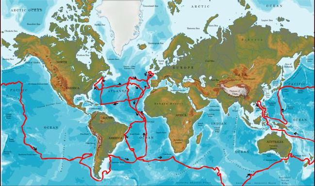
The “Challenger” expedition of 1872–76 was a scientific exercise that made many discoveries to lay the foundation of oceanography. The expedition was named after the mother vessel, HMS “Challenger”.
During its almost four-year journey, the “Challenger travelled nearly 70,000 nautical miles surveying and exploring.
The result was the multi-volume “Report Of The Scientific Results of the Exploring Voyage of HMS. ‘Challenger’ during the years 1873-76″ which, among many other discoveries, catalogued over 4,000 previously unknown species.
John Murray, who supervised the publication, described the report as “the greatest advance in the knowledge of our planet since the celebrated discoveries of the fifteenth and sixteenth centuries.”
As recently as the late 19th century, human knowledge of the oceans was confined to the topmost few fathoms of the water and a small amount of the bottom, mainly in shallow areas. Sailors and scientists knew almost nothing of the ocean depths.
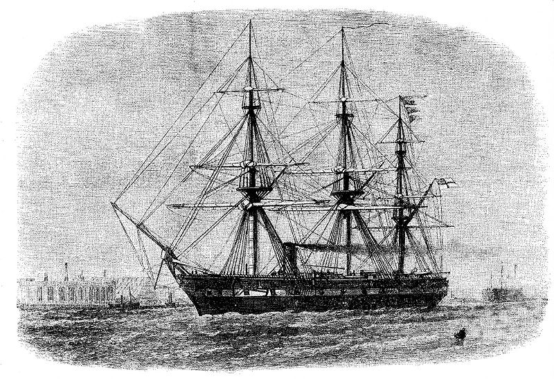
HMS “Challenger” was a 2000-ton, 225-foot steam-assisted Royal Navy Pearl-class corvette launched on 13 February 1858. To enable her to probe the depths, the “Challenger’s” guns were removed and her spars reduced to make more space available.
Laboratories, extra cabins and a special dredging platform were installed. She was loaded with specimen jars, filled with alcohol for preservation of samples, microscopes and chemical apparatus, trawls and dredges, thermometers and water sampling bottles, sounding leads and devices to collect sediment from the sea bed and great lengths of rope with which to suspend the equipment into the ocean depths.
Because of the novelty of the expedition, some of the equipment was invented or specially modified for the occasion. In all she was supplied with 181 miles of Italian hemp for sounding.
Arriving in Bermuda for the first time in April, 1873 “Challenger” recorded that the island “is undulating and well wooded,” “cumbered with a luxuriant vegetation of palmettos, mangroves, junipers, and ferns,” and a source of potatoes, tomatoes, and onions for the New York market.
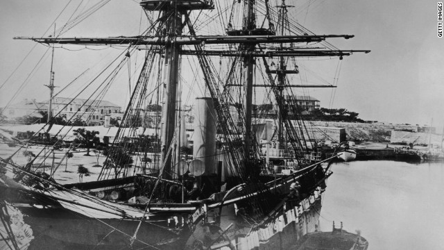
HMS “Challenger” moored at Bermuda’s Royal Naval Dockyard
Joseph Matkin — the ship’s steward’s assistant for the “Challenger” voyage — was a prolific letter writer and his impressions of life aboard the ship as well as his vivid descriptions of the ports she called in provide a detailed record of day-to-day life during the expedition.
“At 2pm on the 3rd of April the Bermuda islands hove in sight, the land being wonderfully low for islands in the middle of the ocean, and looks very bleak and bare from the distance, but when we arrived in close it had a better appearance,” Matkin said. “… The Bermuda islands all belong to Great Britain and are about 300 in number, but the whole lot are no larger than St. Thomas. Bermuda itself is the largest, and Hamilton the chief town is bult on it, the whole population is about 12,000 and the greater portion are colored people.
“The islands were discovered in 1527 by Bermudez a Spaniard, who named them after himself. In 1609, Admiral Sir George Somers was wrecked on the islands and founded the Colony; and they have belonged to the British ever since.
“There is a fine fortified Dockyard, on one of the islands and an immense iron floating dock, for the convenience of re-fitting the fleet stationed in North American waters, without sending them home. This immense dock was built at Woolwich, and towed across the Atlantic a few years ago, by four of our larges Ironclads. This place would be of great importance as a rendezvous for the Fleet &c, in case of a war with America; it is 5 days sail from New York, and 800 miles from the nearest land, Cape Hatteras [North Carolina] in North America.”
On April 2, 1873 a day was spent “sounding out” the shoal off Bermuda’s southwest coast which became known as Challenger Bank.

“About four miles southwest of the southwest extremity of the 100 fathom edge of the Bermuda Bank the ‘Challenger’ sounded and anchored on the ‘inner bank’ … in 30 fathoms, with Gibb’s Hill lighthouse, N. 540 14′ E. [true], distant 13 miles,” reads the official account. “The boats were employed one day in obtaining soundings on this bank, but owing to the rough weather rendering the men sick, and to the barometer falling, the officers were unable to define its limits or to look for the ‘outer shoal’, out of sight of land, on which the ‘Columbine’ anchored in 1820, and on which soundings were also taken by the ‘Larne’ in 1836.
“From the depths obtained, the inner or Challenger Bank appears to be of some extent, certainly not less than 10 miles in circumference, the shallowest water found being 24 fathoms, and it is quite possible that it joins the outer or ‘Columbine’ Bank, or that at any rate the depths between the two do not much exceed 100 fathoms.
“In the depression, 3i miles wide, between the Challenger Bank and the southwest extremity of the Bermuda Bank, the soundings, in all probability, do not exceed 1000 fathoms, as a cast of 1075 fathoms was obtained just east of the northwest part of the depression and another of 1250 fathomsjust west of it.
“Circumstances did not permit of the definition of the edge of the 100 fathom bank on the northwest side of the Bermudas, but a cast of 1370 fathoms was obtained at a distance of 6 miles from the rocks awash, and one of 2100 fathoms at a distance of 10 miles. The deepest sounding obtained close to the atoll was one of 19.50 fathoms, five-and-a-half miles west of the extreme west point of the rocks awash.”
Map showing the route of HMS “Challenger” during its epic voyage
Aside from its pioneering oceanographic work in the seas around Bermuda — research which confirmed the island sat atop a vast seamount, towering more than two miles high from its base on the seafloor – HMS “Challenger’s” scientists also compiled detailed reports on the local geography, flora and fauna.
“The scenery of Bermuda is in some respects not unlike that of certain northern lake districts, for the numerous small islands which are dotted over the sounds and land-locked sheets of water are covered with vegetation down to the water’s edge,” says the record of the voyage. “The dark colour of the Juniper Juniperu Bermudiana, a species peculiar to these islands and the West Indies, called in the island ‘Cedar,’ the prevailing foliage, not unlike that of Pines in appearance, gives the landscape a northern aspect, and on cloudy days, the island, as viewed from the sea, looks cold and bleak The extreme lowness of an the land, however, is characteristic and distinctive.
“Most conspicuous, next to the Juniper as a general feature in the vegetation, is probably the Oleander [Nerium oleander], which, having been introduced, flourishes everywhere. A large portion of the uncultivated land is covered with a dense growth of another introduced plant, Lantana camera, a most troublesome weed.
“The most refreshing and beautiful vegetation in Bermuda is that growing in the marshes and caves. The marshes or peat bogs lie in the inland hollows between two ranges of hills, and are covered with a tall luxuriant growth of ferns.”
BIOS “On The Rock Report” in which Bermuda students recreate HMS “Challenger’s” depth soundings

Read More About
Category: All, Environment, History
what an interesting article – thank you Bernews!