
Ministry Issues Advisory On Hurricane Cristobal
The Ministry of National Security has issued an advisory about Hurricane Cristobal, saying that the latest weather reports indicate that Hurricane Cristobal is expected to remain a Category 1 Hurricane as it passes by Bermuda around 6.00 a.m. Thursday morning.
The Ministry said, “Cristobal is currently forecast to pass around 200-250 nm to our west through northwest during Wednesday night/Thursday morning. Tropical Storm force winds [sustained 34 knots] extend nearly 180 nm from the center towards Bermuda’s direction and will likely reach the Island’s western and northwestern marine area late Wednesday into early Thursday.
“The BWS advised however, that only a slight chance of sustained tropical storm force winds reaching the Island is possible, and those will most likely be experienced in elevated and exposed areas. More probable is the return of occasionally heavy rainfall to the Island, on the order of 1-2 inches. Seas with southwesterly swells are expected to briefly reach or exceed 20 feet on Wednesday into early Thursday.”
Premier and Minister of National Security, Michael Dunkley, who is also chairman of the Emergency Measures Organisation, said the Government body continues to closely monitor the storm’s progress.
Premier Dunkley said, “I have been kept fully abreast of Hurricane Cristobal’s progress by the BWS. While latest reports indicate that we are expecting mostly a marine event with this storm, we are encouraging residents not to be complacent. Make sure that your property is secured and check your storm kits – don’t wait until the last minute to check for your supply of batteries, fuel for your car or bike and even your generator.”
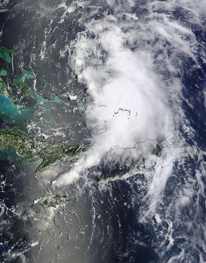
NASA’s Aqua satellite captured this visible image of Cristobal yesterday:
The full statement from the Ministry is below:
Latest weather reports indicate that Hurricane Cristobal is expected to remain a Category 1 Hurricane as it passes by Bermuda around 6.00 a.m. Thursday morning.
The Bermuda Weather Service [BWS] advises that the Island will remain under a Tropical Storm Watch until the center of Hurricane Cristobal has passed its closest point of approach and tropical storm force winds are no longer a possibility in our marine area [25 nm surrounding Bermuda].
Cristobal is currently forecast to pass around 200-250 nm to our west through northwest during Wednesday night/Thursday morning. Tropical Storm force winds [sustained 34 knots] extend nearly 180 nm from the center towards Bermuda’s direction and will likely reach the Island’s western and northwestern marine area late Wednesday into early Thursday.
The BWS advised however, that only a slight chance of sustained tropical storm force winds reaching the Island is possible, and those will most likely be experienced in elevated and exposed areas. More probable is the return of occasionally heavy rainfall to the Island, on the order of 1-2 inches. Seas with southwesterly swells are expected to briefly reach or exceed 20 feet on Wednesday into early Thursday.
Those living in low lying and coastal areas are encouraged to make the necessary residential preparations in advance of Cristobal. Additionally, as a precaution, those who own boats and watercraft are encouraged to secure their vessels in advance of the storm.
As a general reminder, the public will be aware that Hurricane season officially began June 1, and concludes November 30. With that in mind, residents are encouraged to ensure that their storm kits are up to date.
This afternoon, the Premier and Minister of National Security, the Hon. Michael Dunkley, who is also chairman of the Emergency Measures Organisation (EMO) said the Government body continues to closely monitor the storm’s progress.
Premier Dunkley said, “I have been kept fully abreast of Hurricane Cristobal’s progress by the BWS. While latest reports indicate that we are expecting mostly a marine event with this storm, we are encouraging residents not to be complacent. Make sure that your property is secured and check your storm kits – don’t wait until the last minute to check for your supply of batteries, fuel for your car or bike and even your generator.”
People can get the latest weather information by tuning in to or logging on to the following:
- Hurricane preparedness: www.emobermuda.com
- Online weather updates: www.weather.bm
- FaceBook updates: www.facebook.com/dciBermuda
- Televised weather updates: CableVision Ch. 4 and WOW Ch. 100
- For The Public Forecast: Dial 977
- For The Current Observation: Dial 9771
- For The Marine Forecast Dial: 9772
- For Latest Warnings & Tropical Information: Dial 9773
- Government’s Emergency Broadcast station is on 100.1 FM
The Ministry advised that other preparation tips are as follows:
Roof And Tank
Block the gutters with clean rags or other device to prevent any leaves, salt and other contamination from entering your water tank.
Windows & Doors
Installing storm shutters over all exposed windows and other glass surfaces is one of the easiest and most effective ways to protect your home. Cover all windows, French doors, sliding glass doors and skylights. Plywood shutters that you make yourself, if installed properly, can offer a high level of protection from flying debris during a hurricane.
Outdoor Furniture
Bring in outdoor objects such as lawn furniture, toys and garden tools; anchor objects that cannot be brought inside but that could be wind-tossed. Remove outdoor antennas, if possible.

Read More About
Comments (3)
Trackback URL | Comments RSS Feed
Articles that link to this one:
- Bermuda Fed Team Defeats Lasell At Home | Bernews.com | August 27, 2014
Gotta love it.
Ministry of National Security.
Crisstaboll is coming.
Gotta keep the civil servants employed