
Keeping Watch On Hurricane Teddy
As the island continues to finalize the recovery from Hurricane Paulette, many are keeping an eye on Hurricane Teddy, which is currently far away, however the NHC has advised that it “could become a major hurricane.”
The latest forecast from the U.S. National Hurricane Center said, “At 1100 AM AST [1500 UTC], the center of Hurricane Teddy was located near latitude 16.5 North, longitude 49.7 West. Teddy is moving toward the northwest near 12 mph [19 km/h] and this general motion is forecast to continue for the next few days.
Graphic courtesy of the NHC:
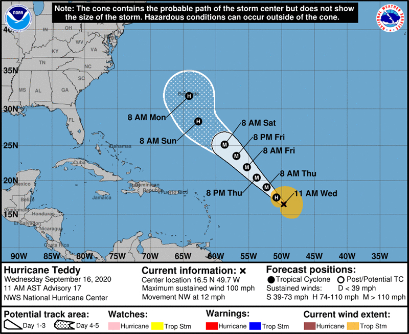
“Maximum sustained winds are near 100 mph [155 km/h] with higher gusts. Additional strengthening is expected over the next couple of days, and Teddy could become a major hurricane by late tonight.
“Hurricane-force winds extend outward up to 30 miles [45 km] from the center and tropical-storm-force winds extend outward up to 195 miles [315 km]. The estimated minimum central pressure is 978 mb [28.88 inches].”
The NHC forecast discussion said, ” On the forecast track, Teddy could make a close to approach to Bermuda in about 5 days. However, based on average 5-day track and intensity errors, it is too soon to know what type of impacts the cyclone could have on the island.
The BWS website continues to have technical difficulties, so they have not listed Teddy as of yet, however the website issues are IT related, and the meteorologists at the BWS continue to work and are keeping an eye on all storms in the area, including Teddy.
“The latest guidance from NHC has the track of Teddy heading in our general direction. However, it is still to early for certainty on the track and intensity of Teddy,” the BWS told Bernews.
“NHC’s forecast discussion for the noon update has some additional information and we do not have more insights to add to that at this time.”
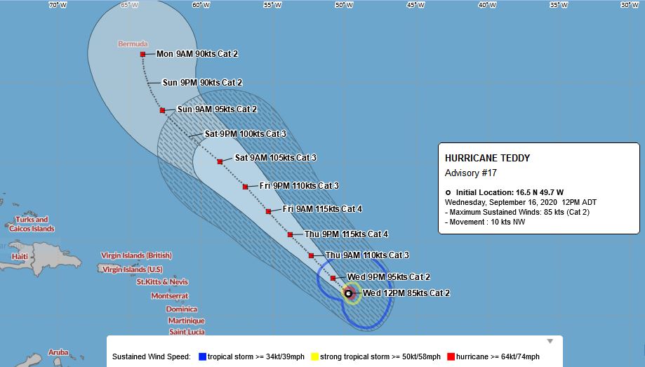
Graphic via the BWS:


Everything crossed the GFS is the more accurate model, and not ECMWF.
I am not sure why the major US weather information outlets continue to use the US modelling for Hurricanes when the European models have consistently been more accurate over time. Paulette’s European track on general timing and placement was accurate except for intensity and forward speed in the stages when on our doorstep and moving over us- that margin of error is fine by me, especially when the forecast was for stronger and it was less so- better that, than the other way around.
EU one isn’t free is it? US one is.