
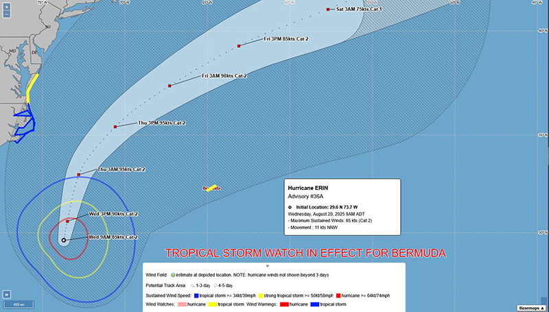
Hurricane Erin: BWS Issue ‘Tropical Storm Watch’
The Bermuda Weather Service [BWS] has issued a Tropical Storm Watch, and noted that Hurricane Erin is “a potential threat to Bermuda” with its nearest forecasted point to the island being 320 nm to the north-west at 10pm on Thursday [August 21] with the BWS noting that “this forecast is subject to change with the next update.”
Graphic courtesy of the BWS:
The latest forecast from the U.S. National Hurricane Center said, “At 800 AM EDT [1200 UTC], the eye of Hurricane Erin was located by an Air Force Hurricane Hunter plane near latitude 29.6 North, longitude 73.7 West.
“Erin is moving toward the north-northwest near 13 mph [20 km/h]. A turn toward the north and north-northeast is expected today and tonight, followed by a faster motion toward the northeast and east-northeast by Thursday and Friday. On the forecast track, the center of Erin will move over the western Atlantic between the U.S. east coast and Bermuda today through early Friday, and then pass south of Atlantic Canada Friday and Saturday.
Graphic courtesy of the NHC:

“Maximum sustained winds are near 100 mph [155 km/h] with higher gusts. Some strengthening is possible during the next day or so. Weakening is likely to begin by Friday, but Erin is forecast to remain a hurricane into the weekend.
“Erin is a large hurricane. Hurricane-force winds extend outward up to 90 miles [150 km] from the center and tropical-storm-force winds extend outward up to 265 miles [425 km].
“The minimum central pressure reported by the Air Force Hurricane Hunter aircraft is 948 mb [28.00 inches].”
