
NOAA Predicts Active 2013 Hurricane Season
 In its 2013 Atlantic hurricane season outlook issued this afternoon [May 23], the US National Oceanic & Atmospheric Administration [NOAA] Climate Prediction Centre is forecasting an active or extremely active season this year.
For the six-month hurricane season, which begins on June 1, NOAA’s Atlantic Hurricane Season Outlook says there is a 70 percent likelihood of 13 to 20 named storms [winds of 39 mph or higher], of which seven to 11 could become hurricanes [winds of 74 mph or higher], including three to six major hurricanes [Category 3, 4 or 5; winds of 111 mph or higher].
These ranges are well above the seasonal average of 12 named storms, six hurricanes and three major hurricanes.
“With the devastation of Sandy fresh in our minds, and another active season predicted, everyone at NOAA is committed to providing life-saving forecasts in the face of these storms and ensuring that Americans are prepared and ready ahead of time.” said Kathryn Sullivan, Ph.D., NOAA acting administrator. “As we saw first-hand with Sandy, it’s important to remember that tropical storm and hurricane impacts are not limited to the coastline. Strong winds, torrential rain, flooding, and tornadoes often threaten inland areas far from where the storm first makes landfall.”
Three climate factors that strongly control Atlantic hurricane activity are expected to come together to produce an active or extremely active 2013 hurricane season.
These are:
- A continuation of the atmospheric climate pattern, which includes a strong west African monsoon, that is responsible for the ongoing era of high activity for Atlantic hurricanes that began in 1995;
- Warmer-than-average water temperatures in the tropical Atlantic Ocean and Caribbean Sea; and
- El Niño is not expected to develop and suppress hurricane formation.
“This year, oceanic and atmospheric conditions in the Atlantic basin are expected to produce more and stronger hurricanes,” said Gerry Bell, Ph.D., lead seasonal hurricane forecaster with NOAA’s Climate Prediction Centre. “These conditions include weaker wind shear, warmer Atlantic waters and conducive winds patterns coming from Africa.”
NOAA’s seasonal hurricane outlook is not a hurricane landfall forecast; it does not predict how many storms will hit land or where a storm will strike.
Forecasts for individual storms and their impacts will be provided throughout the season by NOAA’s National Hurricane Centre.
Bermuda marks Hurricane Awareness Week [(HAW] from May 27 through 31. The annual public awareness campaign is run by the Bermuda Weather Service on behalf of the Government of Bermuda.
The aim of HAW is to educate the public and decision-makers, so they can prepare for the threats imposed by hurricanes and tropical storms.
“Preparedness reduces the risk posed by the impacts of these significant weather events,” said a Bermuda Weather Service spokesman.
Last September Bermuda had a close call with Hurricane Leslie, which forecasters had feared “could be a historic storm” because it was intensifying rapidly as it approached the island.
NASA satellite image of Leslie as it passed over Bermuda on September 9, 2012
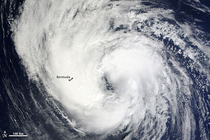
However, the storm passed further east of Bermuda than initially predicted, causing only minor impact. Nonetheless, sustained winds of 39 miles per hour and a gusts up to 54 miles per hour were reported in St. David’s and 3.15 inches of rain was recorded in the same location.
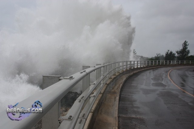
Prior to Leslie, Bermuda’s last significant brush with a hurricane came in 2010 when Igor pounded the island for three days in September with ustained winds that reached 91 miles per hour and gusts which peaked at 117 miles per hour.
Additionally, a storm tide took place in St. George’s [pictured below] As the storm arrived, the island’s airport was shut down earlier than originally planned due to the threat of tornadoes.

Despite initial fears, Igor left relatively little damage across Bermuda.
The last time Bermuda sustained a direct hit from a hurricane was when Fabian ploughed across the island in September, 2003, spawning tornadoes and causing millions of dollars in damage.
NOAA said new for this hurricane season are improvements to forecast models, data gathering, and the National Hurricane Centre communication procedure for post-tropical cyclones.
In July, NOAA plans to bring online a new supercomputer that will run an upgraded Hurricane Weather Research and Forecasting [HWRF] model that provides significantly enhanced depiction of storm structure and improved storm intensity forecast guidance.
Also this year, Doppler radar data will be transmitted in real time from NOAA’s Hurricane Operations Centre Hurricane Hunter aircraft. This will help forecasters better analyse rapidly evolving storm conditions, and these data could further improve the HWRF model forecasts by 10 to 15 percent.
The National Weather Service has also made changes to allow for hurricane warnings to remain in effect, or to be newly issued, for storms like Sandy that have become post-tropical. This flexibility allows forecasters to provide a continuous flow of forecast and warning information for evolving or continuing threats.
“The start of hurricane season is a reminder that our families, businesses and communities need to be ready for the next big storm,” said Joe Nimmich, FEMA associate administrator for Response and Recovery. “Preparedness today can make a big difference down the line, so update your family emergency plan and make sure your emergency kit is stocked.”

Read More About
Category: All, Environment, News
Stay safe!
There. I win. I said it first.
Didn’t they say the same thing last year?!
I hope those forecasters are sooo wrong. As a child hurricanes used to be exciting. That was before being responsible for valuable assets to worry about.